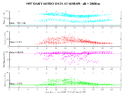
| Figure 5. Meteorological data measured on the field during 1997 GPS campain. They have been reduced with respect to 3000-m elevation using standard vertical profiles of temperature, pressure and relative humidity, and are presented on a single day scale in local time. These data allow to determine a local meteo model of the troposphere for each time period of the GPS measurements, and are introduced in the double difference processing to compute baselines vectors. Introduction of meteo data is essential when the network covers large height differences as is the case for Merapi (1600 m). |
|