Modified from VSI page
Introduction
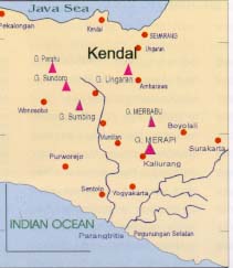
Merapi volcano is situated above the subduction zone between the Eurasian and Indo-Australian tectonic plates. This subduction extends for about 2000 km from Sumatra to the Lesser Sunda Islands. In the Java-Bali sector, subduction occurs between an oceanic plate 10-km in thickness (Indo-Australian) and an intermediate plate of 20-km thickness (Eurasian). This Mesozoic subduction has formed a trench of 6 to 7 km deep.
Merapi volcano was born in period of late Pleistocene - Early Holocene. It is situated at the intersection between two main volcanic alignments Ungaran-Telomoyo - Merbabu - Merapi (N164E) and Lawu - Merapi -Sumbing-Sindoro-Slamet or between two main quartenary faults, Semarang fault (north south) and Solo fault (east west). Among them, Merapi volcano is the youngest one.
Merapi volcano has suffered an evolution. The early stage of its growth, it had a basaltic magma with effusive eruptions. The characteristics of magma then change to more silicic and more viscous. Lava extrusion, thus, may be effusive or explosive. Recently, magma is quite viscous so that it extrudes and accumulates at the crater surface as a lava dome. Since magma is poor in gas, eruption is usually less than 3 in VEI-scale.
Merapi activity is characterized by a very frequent eruption ranging from 1 to 5 years of time duration, weak explosion, and low gas pressure. Eruption is usually accompanied by pyroclastic flows, or "awan panas" in local term or a familiar term "wedhus gembel". There are two types of awan panas: awan panas guguran and awan panas letusan.
Awan panas "guguran" results from collapse of lava domes in the crater of the volcano. Occasionally, a dome might grow so large that it becomes unstable and collapses into several drainage catchments. The distance traveled by the flow and its extent depend strongly upon the volume of the destroyed lava, gas pressure and the slope angle of the flank.
Awan panas "letusan" results from collapse of debris that is erupted vertically. Flow direction depends to some extent on the summit morphology.
Most of the Merapi eruption has low explosivity and the awan panas usually reaches about 6 to 7 km from the summit. Some awan panas have traveled as far as 13 km from the summit, such as the deposit generated during the 1969 eruption. Velocity of pyroclastic flow can reach up to 110 km/hour. Infrared spectrometry of carbonized woods sampled from pyroclastic deposits indicates that awan panas have a temperature range of about 300° - 400° C.
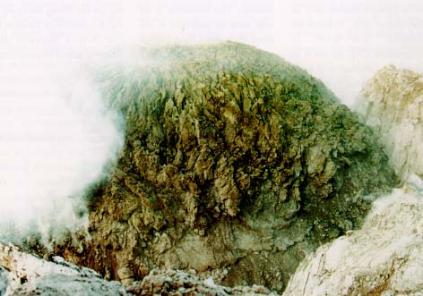
Some eruptive activities at of the Merapi are characterized by dome formation. A slow upflow of andesitic magma leads to an extrusion of viscous magma, which accumulate and construct a dome in the crater. Magma is almost completely degassed and flows out of the conduit with a rate of up to 20.000 m3/day a normal dome formation. The shape and evolution of the dome depend on
The crater configuration. The 1994s dome stays in a slope of about 35° in the horseshoe shaped crater open to the southwest. The core of the dome is viscous and incandescent (looks glowing at night), while the dome crust is solid.
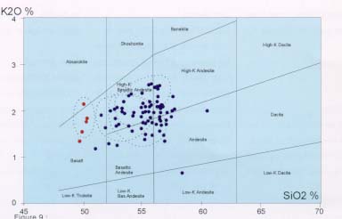
Several studies on geochemistry and mineralogy of Merapi lava and pyroclastic flow indicate that there are three magmatic processes occur within the volcano, which are magmatic differentiation, magma mixing and sediment contamination.
Magmatic differentiation or fractionated crystallization is showed by a progressive evolution of magma from basic, about 50% of SiO2, to more acid, 60% of SiO2. The lack of a great difference in volcanic product indicates that the fractionated crystallization is very limited which may be caused by a frequent supply or injection of deep magma to the system. Chemical composition of certain rocks is related to the stage of lava differentiation. The Merapis basalt flow, at Turgo for instance, in general has a higher Ca than the other lavas of Merapi.
However, the cyclic evolution of SiO2 of Merapi lava does not come from fractionated crystallization. The abrupt change in chemical composition of lava may be explained by the process of a new magma supply.
A glass analysis of the two facies, dark and white, in the 1984s eruption product shows that they are chemically different. The dark component has a higher silica content than the white one. It was inferred that a mixing between magma from shallow pocket with more-acid magma from deeper chamber may have played a role during the 1984 eruption.
The influence of sedimentary contamination in magma was concluded from isotope analysis. There are carbonate contaminations, which may originated from the subduction plate or from shallow crust, from around the magma chamber for instance.
Chronology
Based on structural and so far limited chronological data, evolution of the Merapi volcano can be categorized into 4 periods:
Pre-Merapi:
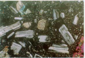
The hill Bibi, 2025 m, in the northeast of the volcano is the oldest part. It has an olive-rich basaltic composition having a SiO2 of 49%. The texture is intergranular with about 73% of crystals. During the formation it cooled slowly which was indicated by the domination of large crystal (1-2 mm). The rock composed from plagioclase, 49.6%, amphibole, 17.4%, clinopyroxene, 3.2%, and magnetite, 2.5%. The high crystallinity and the large number of vesicles indicated that magma was quite viscous. K-Ar dating obtained an age of 0.67 million years, and appears much older than the rest of the volcano.
This period was characterized by basaltic effusive eruption. The main deposits include numerous basalt flows and pyroclastic flows found in Plawangan and Turgo hills. The lavas and pyroclastic flows have a porphyritic texture with a cristallinity ranging from 26.6% to 55.2%. The basaltic lava and pyroclastic flows are characterized by large (1-2 mm), rounded plagioclases. SiO2 has a concentration of 48.9%. A U/Th age of 40.000 years was obtained on a lava flow from Turgo hill.
At Batulawang hill, an andesitic flow overlies a brecciated lava deposit. Initial activity consists of andesitic flow and St. Vincent type pyroclastic flow from the central crater. In the end of the period where Gajahmungkur group was deposited, Pasarbubar crater was the central crater of the Merapi volcano. The rocks of this group have a porphyritic texture. The crystallinity ranges from 41.4% to 54.9%. Radioactive dating gives an age of about 6700 BC.
New Merapi:
This stage is characterized by three types of eruptive product:
The temple Sambisari was mantled by an ash deposit from a major eruption in this period.
Since 600 years ago, activity has been dominated by construction of lava domes or viscous andesitic lava tongue and their destruction either by gravitational effect or/and explosive activity. Pyroclastic flows are normally generated during dome collapse and during explosive activity.
Recent Activity
1791
The summit was occupied by a lava dome facing south and southwest from the Pasarbubar crater. The base of the crater was at a depth 100-130 m from crater rim. It is possible that generation of the crater results from the 1768 eruption. A dome in the crater formed in 1786, 18 years after the 1768s eruption.
1821
In 1797, the summit crater was filled with viscous lava, which built a new dome. The dome formation lasted until 1822.
1822-1823
Eruption was preceded by a big earthquake felt at several places in Java. The first explosion occurred in December 27, 1822 at 09.00, which led to a paroxysm in two and three days later. A strong explosion destroyed the west part of the summit. Ashfall happened at Boyolali, Muntilan and Magelang. A new crater of 600 m wide formed, opened in three directions: Apu, Blongkeng and Woro. Pyroclastic flows swept Apu, Lamat, Blongkeng, Batang, Gendol and Woro rivers. The explosion ceased in January 10, 1823. Several days after, rain triggered lahars which transferred hot material from pyroclastic flows. At mid of January 1823, a new dome started to form inside the crater while created lava flow through the breach of Blongkeng.
1832-1835
In December 25, 1832 about midnight, an explosion crushed the west part of the 1823s dome and produced pyroclastic flow to the direction of Blongkeng and Lamat rivers. This explosion resulted in a new small crater on the dome. Lava filled this crater and covered the rest of the dome. Some earthquakes occurring during this period triggered pyroclastic flows ("awan panas guguran") originating from gravitational collapse of the dome. Later, the pyroclastic deposit were covered by lava flows. The biggest pyroclastic flow formed when a half of the dome collapse.
1837-1838
The similar eruption to the in 1832-1835 one started in April 10, 1837. Almost all the products of 1832-1835 eruption were blown. A new crater formed to the west, adjacent to the last crater. Eruption stopped in February 1838, leaving a morphology similar to those from the 1832-1835s eruption.
1846-1847
In September 2, 1846 at 10:00 am, a big explosion generated a black ash cloud. It was followed then by a series of explosions. The explosion created a new crater facing south -southeast. The dome of 1837-1838 acted as a barrier so that pyroclastic flows were directed to the south through Woro and Gendol. The west part of the summit did not change. The eruption was ended by a dome formation in the crater and some lava flows to the east flank. The cycle of the eruption stopped in October 1847.
1848
It is supposed that there was an eruption in January 8, 1848. An explosion sound was heard, however cloud covered the summit, prevented from visual confirmation.
1849
In April 26 1849, a strong vertical explosion occurred, followed by
pyroclastic flows. The volcano returned to the calm state until September
1949. A series of strong explosion happened in September 14 and 15, 1949
originated from the west part of the summit. Ash deposit was about 3 cm
thick at Muntilan and 1 cm thick in Magelang (25 km). The summit was destroyed.
Blongkeng river was completely covered by pyroclastic flow deposits. In
September 1849, the last explosion of the cycle occurred. A crater of 400
m wide and 250 m deep formed.
1862-1864
The situation was the same as in the period of 1768-1786. After a repose
period of 13 year, lava flow out from the 1849s crater to west direction.
In July 1863, some explosions generated three craters. One of them was
located in the southeast part of the summit to the north adjacent to the
center of activity of 1846. Several pyroclastic flows propagated along
the west slope while lava continued to flow out filing the 1849s crater
and forming a new dome. The dome grew until 1864. During dome formation,
some "awan panas guguran" occurred.
1865-1867
In October 1865, some explosions destroyed part of the summit creating
a horseshoe shaped crater. Inside the new crater a new dome grew. At an
altitude of 2300 m in the upstream of Blongkeng river, a new crater formed
with a lateral dome. Lava flow continue until 1867.
1869
In May 1869, a lava flow occurred in Blongkeng region. In the 1865s
crater the dome grew and cascaded crater walls. It reached an altitude
of 2907 m. Several "awan panas guguran" originated from it. Eruption ceased
in the end of 1869.
1872
In April 15, 1872 the biggest explosion ever known started. There was
no preliminary phase and eruption began with a series of strong explosions.
A big crater "Mesjidanlama" formed with three breaches: Blongkeng, Woro,
Gendol. Pyroclastic flows came out from these three breaches. Some pyroclastic
flows passed also in Apu, Trising and Senowo rivers. All villages 1000
m altitude were destroyed by pyroclastic falls. Explosive phase lasted
in five days. In November 3 and 4, 1872, some new explosions generated
ashfalls.
1878-1879
Two explosive eruptions emitted blocks falling down in the crater of
1872.
1883
In the beginning of 1883, a dome was born in the 1872s crater. It
continued to grow until 1885. In the end of the dome formation dome elevation
had increased from 2900m to 2911 m.
1888
The dome restarted to develop, accompanied by gravitational avalanches
and flows to northwest direction.
1891-1894
There was a growth of the existing dome accompanied by avalanches.
Several explosions occurred generating "falls".
1902-1906
In the end of 1902, a strong fumarolic activity preceded a fast dome
formation in the north and northeast of the summit. Later, it was called
"G.Anyar" (new hill) (or East Dome).
1903
The first stage was dominated by a series of explosion generating ash
falls in the east flank. The outflow rate of lava increased so that some
gravitational avalanches formed through the Woro breach to Woro and Opak
rivers. The advance of magma below the solidified upper part of the dome
resulted in small explosions and pyroclastic flows. The explosion frequency
increase until the beginning of 1904.
1904
After a rest of several days, in January 23, 1904 a first explosion
started, generating ashfalls and lapillis until Boyolali. This explosion
was preceded by an earthquakes. A paroxysmal explosion occurred in January
30, 1904 destroying the eastern part of Gunung Anyar and reformed the Woro
breach. This explosive period continued during 5-6 days. There was a pyroclastic
flows until 6 km along the east slope. Some small explosions continued
until February 6, 1904. A lava flow stayed at the upstream of Woro river.
Occasionally, rain triggered lahar and phreatic eruption. The eruption
ceased about in June.
1905
A new eruption restarted, similar to but smaller than that of 1904.
In June 1905, it generated a pyroclastic flow to a distant of 4 km along
Woro river. Then, the volcano returned to calm state.
1906
In the end of January, there were some small explosions from above
the Woro breach. Eruption became more and more frequent and stronger and
stronger. This led to a strong explosion in February 28, 1906. Pyroclastic
flow open the Woro breach from where lava-flow originated. This flow covered
1904-1905s products. In May, a phreatic explosion produced a depression
on the lava flow from where two scoria cones formed.
1909-1913
The volcanic activity shifted to the northwest sector of the summit.
In February 1, 1909, a destructive explosion generated a crater of medium
size compared to those of 1822 and 1872. Pyroclastic falls happened in
the northwest slope. In 1911, a dome formation started which is called
as West Dome to distinguish from East Dome (Gunung Anyar), the product
of 1902. In 1913, the dome was 58 m higher than and partly covered the
East dome. It culminated at an elevation of 2968m. It extended laterally
to northwest orientation. The eruption stopped in May 1913.
1915
From March 28 to May 15, a new cycle restarted, initiated with a minor
explosion. The cycle was terminated by a filling of the resulted crater
with amount of viscous lava.
1920-1924
In July 25, 1920, an explosion destroyed the upper part of the West
dome in a form of horseshoe shaped valley. In that position born a new
dome which then was exploded in February 1921. The West Dome, which partially
corroded by the 1921 eruption reformed. In February 18, a series of explosion
created a small breach in the west part of the West dome which allowed
lava to flow through. The lava flow stopped in August 8, 1922. The center
of the lava extrusion was to the west adjacent to the point where the West
dome was born.
1930-1931
Preliminary phases consisted of appearance of tremors recorded at Maron,
9 km from the volcano using Bosch-Omori seismograph installed in February
1924. Tremor occurred at almost all along 1930. A strong tremor preceded
the first lava flow in November 21, 1930. Lava appeared at 2700m elevation,
250m below the summit. The paroxysmal phenomena occurred in December 18
and 19, 1930 in a form of strong explosions and pyroclastic flows. The
strongest pyroclastic flow reached a distance of 15 km along Blongkeng
river. About 20 km2 of area was burned. Thirteen (13) villages were swept
completely, 23 were partially. About 1369 persons were killed, and 2000
animals died. A huge depression was created in the west part of the summit.
It has about a length of 850 m in a east-west orientation and a maximum
depth of 850 m. The depression extended from the summit to an elevation
of 2150 m, thus about 700 m of altitude difference. In January 1931, a
effusive phase started. Lava came out from the most upper part of the depression.
Due to the morphology of the depression, lava built a dome of "coulee"
type while producing glowing avalanches. The avalanches increase in the
number in June and July. Eruptive activity stopped in the middle of September
1931.
1933-1935
In October 1, 1933, an explosive eruption produced a small crater and
generated small pyroclastic flows. In 1934, the lava crept along the small
crater forming a dome. The activity stopped in April 1935.
1939-1940
Three "ultra vulcanian" explosion occurred in December 13 and 23, 1939
and in January 24, 1940 from the upper part of the 1930s dome. Then lava
came out from the explosion depression forming a dome without any accompanying
avalanches. The dome filled completely the depression in August 1940. In
the end of 1940 and in January 1941, the center of the dome top decreased
due to the lowering temperature.
1942-1943
Three explosions occurred in May 30 1942, June 8 and 20, 1942. One
of the explosions took place in the north part of the crater. The others
were located in the southeast part. A new dome was born in the west par
of the 1940s dome and it grew until March 1943. From March 5 to April
11, 1943, some explosions create the Batang breach. In the night of April
11 a noisy sound of about 2 hours was heard. About 130.000m3
of ash emitted. In April 12, 1943, effusion started through the Batang
breach accompanied by lava and pyroclastic flows. In the end of the activity,
in May 1943, it was estimated that the lava volume extruded was about 2
million m3.
1944-1945
Several explosions were inferred from seismogram. Possibly, it was
only a continuation of the 1943 cycle in a form of a dome growth.
1948-1949
In September 29, 1948, an explosion happened and initiated a dome formation.
The resulted dome was in a form of "coulee".
1953
In March 2, 1953, ash fall covered the slope of the volcano. Lava extrusion
occurred in the north flank of the summit.
1954-1955
In June 18, 21, 1954, a series of explosions generated ash cloud and
ash falls. Pyroclastic flow swept the north slope killing 64 persons. A
flow of lava covered the upper part of the 1953s dome. The eruption ceased
in 1955.
1956
An explosion initiated an eruptive phase which then followed by lava
flow in the north flank superposing those of 1953 and of 1954.
1957-1959
An explosion occurred in the southern part of the 1930s crater. It
created an ash plume. Lava flow formed a "coulee" dome extending to the
west and covered those of 1931 and 1934. Dome formation lasted until 1959.
1961
After a repose period of 2 years, activity restarted in March 19, 1961.
Until April 11, 1961, pyroclastic flows passed through Batang breach. In
that day, an incandescent lava was observed indicating that it was a new
lava. The second point of the activity was located in the center of the
1957s lava extrusion. It produced avalanches to the Senowo river. One
of the pyroclastic flow reached 6 km along Batang and Senowo rivers. In
April 18, 1961, a 6,5 km pyroclastic flow occurred in Batang river, destroyed
a village partially. In April 20, 1961, an explosion opened the crater
close to the Batang breach and produced a cloud of 1 km high. In May 7,
1961 during 20 minutes incandescent lava was projected to 150 m high to
the Batang upstream. Hot ash fall continued along the day. Some pyroclactic
flows were also in Senowo, Woro and Gendol directions. The paroxysmal explosion
occurred in May 8, 1961 at 15.00 oclock. In the next day, the strongest
explosion lasted for about 30 minutes and generated a pyroclastic flow
until 12 km along Batang river. After the paroxysmal phase, activity gradually
decreased in a form of effusive lava outflow. A new dome of about 200.000
m3 occupied the resulted crater. Dome formation continued until November
1961. The total volume of lava extruded during the cycle was estimated
about 13 million m3.
1967-1968
In January 12, March 3, April 11 and 17, 1967, some successive explosion
widened the 1961s crater. Pyroclastic flows passed in Batang river. In
October 10, 1967 a new dome appeared in the crater at an altitude of 2600
m. In May 1968, the "coulee" dome had a length of 900 m with a volume of
5.9 million m3. During a dome formation there was an average
lava flux about 28.000 m3/day.
1969-1970
In the morning of January 7, 1969, an explosion generated a explosion
column of about 3000 m and pyroclastic flow up to 7 km to the Batang and
Krasak rivers. The next day, tremor and earthquakes occurred frequently.
Explosion sound was heard until Yogyakarta. Pyroclastic flows attained
8 km in Bebeng and Blongkeng river and 13 km in Batang river. The 1967s
dome was completely blown. In January 1969, a new dome appeared. Incandescent
avalanches occurred every 10 minutes, up to 2 km. The dome has a length
of about 400-m and a width of 125 m.
1972-1973
In October 6, 1972 at 07:30, a gas explosion produce a column of 3000
m high accompanied by lightning. Ash deposit was about 1.5 mm in Babadan,
4 km from the summit. In December 13, 1972, a new explosion produce a column
of 700 m high and ash fall until 7.5 km from the summit. In June 1973,
emitted material was estimated to be 4 million m3. Eruption
ceased in the beginning of 1974.
1976-1978
Before the eruptive explosion, there was an existing dome of about
1.4 million m3. In March 6 and 12, 1976, pyroclastic flows reached
a distance in Batang, Bebeng, Blongkeng rivers. Explosive eruption occurred
in March 1976. In March 9, 1976, one third of the dome was destroyed. In
June 1976 a new dome was born in a crater with a volume of 20.000 m3.
The dome continued to grow until 1978 that finally attained a volume of
2.5 million m3.
1979-1984
In January 1979, a series of explosion destroyed partially the 1976s
dome and a new one formed on the rest of the 1973s and 1976s domes. In
August the last pyroclastic flow reached a distance of 6 km. In October
the dome had a height of about 100m. It attained a volume of 1.14 million
m3 in November 1979. The average flux of lava outflow was about 100.000
m3/month. The dome continued to grow until 1984 with a small rate
1984
This was the first explosion monitored by the permanent seismic network.
The first earthquakes of VA type occurred in May 27 1984, less
than three week before the explosion. The number of VA an VB
events started to increase in June 5 1984, with about one to two events
per day until June 10, 1984. In June 11, 1984 VA and VB
increased strongly which lead to the first pyroclastic flow in June 13,
1984 03.30 a.m.. During 3 hours-uninterrupted pyroclastic flows and avalanches
from the dome continued. About noon of June 14, 1984, activity ceased.
Until midnight, there were only several small avalanches.
A strong explosion occurred in June 15, 1984 at 02.15 am., terminating the repose phase. It produced a pyroclastic flows along Blongkeng, Putih, Batang and Krasak rivers. In the river Putih, it attained about 7 km from the summit. The explosion column was 6 km and generated ash falls until Weleri, Kendal and Semarang, 80 km from the volcano. The second and the third explosion happened at 03.47 am. and 06.00 am, respectively. Activity continued with small pyroclastic flow and incandescent avalanches. In the night of June 15, it was confirmed that the crater had been emptied. This means that the rest of the 1979 dome, 3.6 million m3 had been completely thrown out. Post-explosion activity was dominated by lava flow during 10 days which then followed by a dome formation. The new dome occupied the position of that of 1979. The dome formation ceased in March 1985.
1986
The 1984s dome stayed stable until October 1986. In October 10, 1986
suddenly a pyroclastic flows occurred preceded by a strong rain in the
summit. There was no seismic precursors in this activity. During 5 days,
pyroclastic flows continued to happen. In October 15, 1986, the dome grew
until the end of 1987. Between October 1986 and January 1987, the whole
body of the dome change with an average flux of lava was about 15.000 m3/day.
After February 1987, only the upper part of the dome grew. When it stopped
growing, it was estimated that its volume was about 2.5 million m3.
1989-1992
After the disappearance during 4 years since June 15, 1984, 2 VA
earthquakes earthquake occurred in 1988. In 1989 there, seismic activity
remained unimportant, only about 4 events per month. In 1990, the number
of seismic event gradually increased which led to a swarm of 200 VB
event accompanying a gas column of 1 km high from the crater. In 1991,
almost all types of Merapi earthquakes appeared: VA, VB,
LF and tremor. It culminated in September 1991 without any important volcanic
activity. During 4 months from October 1991 to January 1992, the number
of earthquakes lowered. Observers in Ngepos and Babadan posts reported
that an incandescent avalanche occur in January 20, 1992. In January 31,
1992, a visual team climbed the summit and saw that a new rounded dome
was born in the northeastern part of the crater behind that of 1986. Explosion
started in February 2 at 16.05, preceded by several small pyroclastic flows.
It produced an ash column of 2.6 km high and was accompanied by a pyroclastic
flow of 4.5 km long in Sat river. Explosive ceased at 22.30. The activity
change to a dome formation, 1992s dome, until July 1993.
1994
The activity in 1994 can be distinguished in five successive steps.
First: creep of lava block in the upper part of the 1992s dome.
About 90.000 m3 of lava crept to south-southwest with a lateral
speed of 0.18 m/day in December 1993. In January 1994 it accelerated to
0.5 m/day.
Second: born of 1994 dome. In February 1994, a new lava was observed located in the top of 1992s dome in the fracture separating the active block from the stable part of 1992s dome. The new lava pushed the active block so that some small pyroclastic flows formed from the collapse of the block from March 9 to April 8, 1994. They traveled mostly in Bebeng river up to 1.7 km. Until May 1994, the rate of the new lava was about 6500 m3/day.
Third: From May to June 1994, the lava flux increased to 17.000 m3/day in average. In the period of July-August 1994 the dome formation continued with a rather small rate than that in June 1994. It was found then, that the dome had reached the eastern rim of crater, and some of then cascaded to the Gendol solfatara field. In the end of September 1994, the domes volume was about 2.5 million m3. The dome became stable during three months which was indicated by disappearance of Guguran (rockfalls or avalanches). Even though there were several MP events, the morphology of the dome did not show any changes. Fourth: collapse of the 1994s dome. Almost the whole of the dome collapsed in November 22, 1994, producing pyroclastic flow along Boyong river up to 6 km from the summit. the village of Turgo was burned by the hot cloud. The village had never been touched by any pyroclastic since hundreds of years.
Fifth : A new dome formation replaced the collapsing dome. Later , it is called as the 1995s dome.