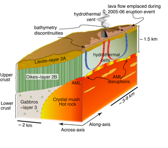
Geophysical signatures of melt distribution along the East Pacific Rise (EPR)

My research at the EPR has been focused on the axial magma lenses (AMLs) and presence of melt within. To do this I have been using high-resolution multi channel seismic dataset collected in Summer 2008 aboard R/V Marcus G. Langseth.
Me aboard the R/V M. G. Langseth (photo credit M.Xu.)
1) The results of my work provided evidence for presence of multiple sub axial magma sills (SAMLs) throughout the lower oceanic crust and suggested hydraulic connectivity between the lenses as the mechanism behind the last documented eruption event at the EPR.
2) Introduced a new method adapted from oil-industry for estimating melt content within the AML along the EPR, showing that the process of melt mixing within a single magma lens is limited.
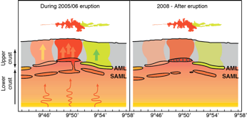
Scenario for the 2005-06 eruption.
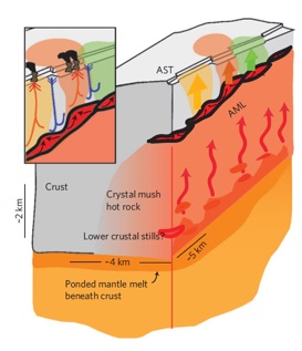
During the eruption,compositionally distinct magmas intruded primarily vertically (arrows) from magma sill segments mapped directly below the eruption site (left). After the eruption, the AML and SAML beneath the central eruption site are partially (AML cross-hatched pattern) to fully (SAML gap) crystallized owing to draining of melt during the eruption (right).
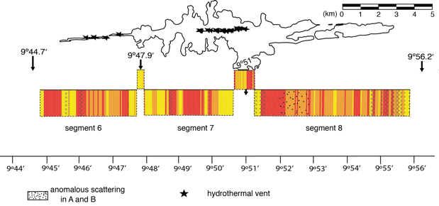
Schematic illustration of the along-axis variations in melt content of the AML from AVA crossplotting analysis. Results are shown for the segments underlying the last documented eruption region. Black arrows indicate fine-scale segmentation in AML (Carbotte et al. 2013).
*
3) corroborated presence of genetic relationship between fine-scale tectono-magmatic segmentation at the EPR.
Schematic representation of EPR magmatic system and 2005–2006 eruption. Segmented magma lens (red) sits atop zone of crystal mush and SAMLs. During dyking, compositionally distinct magmas intrude primarily vertically from AML segments. Possible factors contributing to AML segmentation include lower crustal melt focusing, intrusions/eruptions and melt accumulation within the AML, and variable cooling of AML through hydrothermal circulation (figure from Carbotte et al, 2013).
Variations in crustal structure at Juan de Fuca Ridge (JdF)

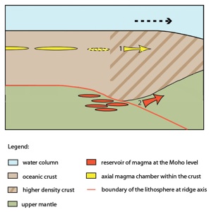
Schematic illustration along the axis of a propagating ridge, summarizing results from our gravity and seismic data analysis. Higher‐ density crust is found within the propagating ridge tip region and is attributed to the presence of FeTi enriched crustal rocks. High extents of fractionation to form FeTi enriched magmas may occur within magma lenses located within the crust (1) and/or beneath the crust (2) with lateral delivery of magma to the propagating ridge tip.
Analyzing gravity data coregistered with multichannel seismic data from the JdF Ridge and flanks to better understand the origin of variations in topography and seismic structure observed along the Juan de Fuca Ridge axis and in the vicinity of pseudofaults on the ridge flanks left by former episodes of ridge propagation.

Trans-Atlantic imaging of the Lithosphere - Asthenosphere Boundary

Bathymetry map showing the TransAtlanticIlab profile (white) with age of the lithosphere (light blue lines). The numbers indicate the age of lithosphere in million years. The red dashed line marks the position of the Mid-Atlantic Ridge, where the age of lithosphere is zero. The yellow lines mark the position of the transform faults (solid) and fracture zones (dashed). Black dashed lines mark the Greenwich meridian and the Equator.
Until now, the nature of the lithosphere-asthenosphere boundary (LAB) has been constrained by teleseismic data, which has resolution of tens of kilometres and sample the LAB sparsely. Seismic reflection imaging technique, in contrast, can provide both lateral and vertical resolution of a few hundred meters, but has not been used for imaging deep structures, thus so far. In March-April 2015, we acquired over 2,750 km of ultra-deep seismic reflection data in the Atlantic Ocean. To image LAB variations as a function of age one of our profiles extends continuously starting from 75 Ma old oceanic lithosphere off the margin of Africa, crosses the Mid-Atlantic Ridge at zero age, to up to 25 Ma old South America lithosphere. To image large differences in the LAB depth we also cross three major fracture zones in the equatorial Atlantic. For imaging deep structures, we used a very large energy source, 10,170 cubic inches, rich in low frequencies and a 12 km long multi-component streamer allowing to record low frequency energy reflected from deep earth and remove reverberation in the water column. Initial results show reflected seismic energy from 50-60 km depth.

Click here for more information on the Trans-Atlantic iLAB project
3D Full Waveform Inversion on Seismic data at the East Pacific Rise - 3DWISE Marie Skłodowska Curie Fellowship
To map crustal properties at an unprecedented resolution scale and unveil the existing link between tectono-magmatic, volcanic and hydrothermal systems, I propose to apply an advanced three-dimensional (3D) full waveform inversion (FWI) technique, which has been recently developed in partnership with industry, to a unique 3D seismic reflection data acquired at the East Pacific Rise. The proposed work will not only result in detailed spatial characterization of the upper crust, but also lay foundation for the 3D FWI as a standard tool for 3D geophysical subsurface exploration of, but not limited to, global tectonics.