Evidence for Erosional Efficiency of Extreme Precipitation Events at a Multi- Decadal Time Scale
DOI : https://doi.org/10.1029/2024JF007818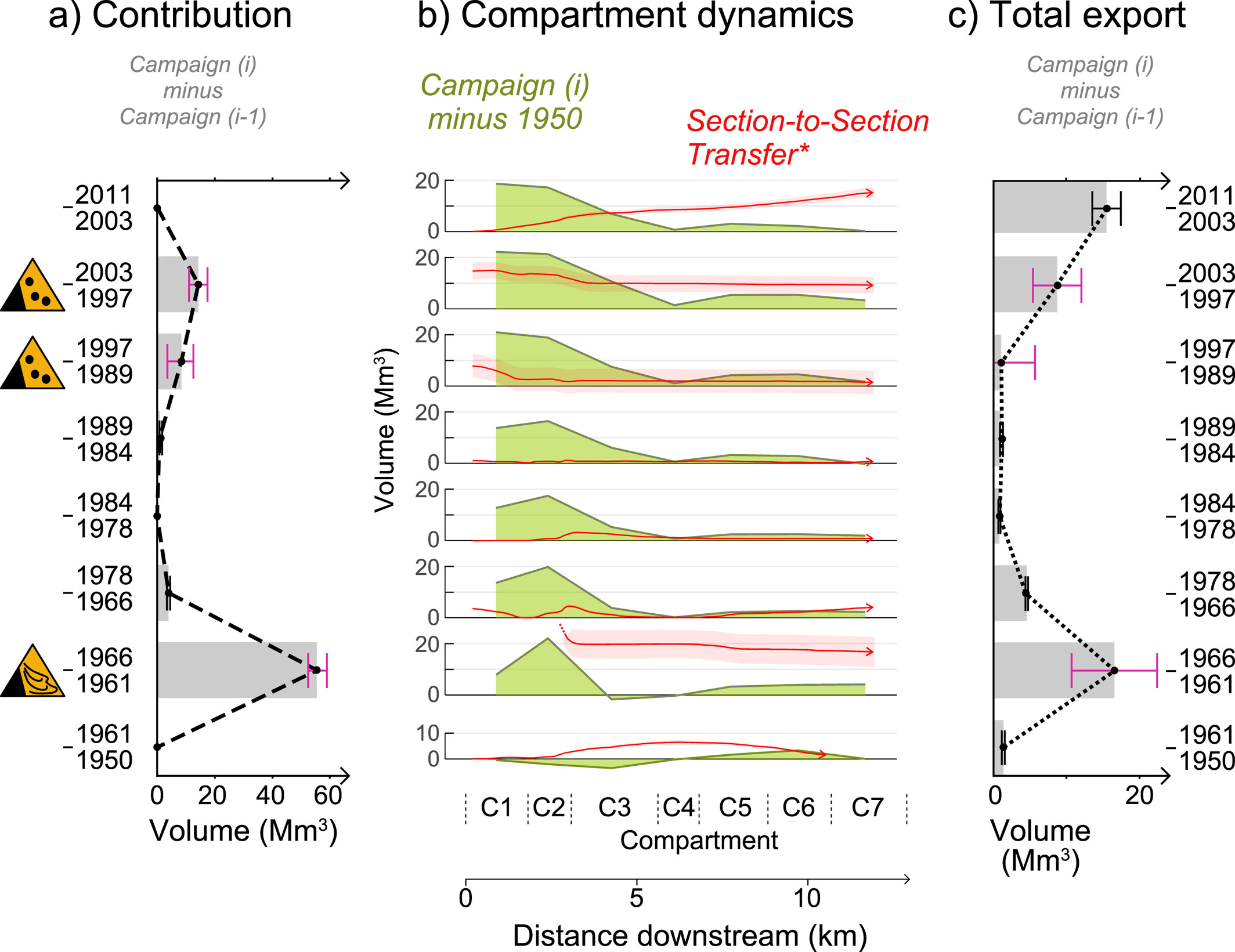
Extreme precipitation events play a pivotal role in shaping Earth's surface through their influences on hillslope processes (triggering mass‐wasting events) and on transport capacity and dynamics of rivers. This study investigates the impact of such events on sediment transport using Réunion Island as a natural laboratory due to its intense tropical rainfall regime. Through photogrammetric techniques using historical aerial images, we reconstructed nine DEMs of the entire canyon bed of the ephemeral Rivière des Remparts spanning six decades. Based on differences in DEMs and sediment volume estimates combined with cosmogenic 3He measurements, we assessed the spatio‐temporal evolution of the entire canyon bed and the drainage of products from major landslides and rock avalanches between 1950 and 2011. Results indicate that 50.2 ± 8.4 Mm3 (145.5 ± 24.4 Mt) of sediment was transported out of the watershed over 62 years via bed load waves. We modeled the flow dates and showed that such an export of material occurred during only 391 days over the 62 years, at an average rate of 0.13 ± 0.02 Mm3/day (0.37 ± 0.06 Mt/day). Our investigation confirms that sediment transport coincides with officially recorded extreme meteorological events such as cyclones. Moreover, our findings reveal that sediment transport predominantly occurs on days corresponding to high‐ percentile rank precipitation events, demonstrating that all transport is concentrated during these intense rainfall periods. Finally, we underscore the extremely fast conveyance of material from slopes to deep‐sea fans, facilitated in Réunion by the absence of a coastal platform.
The 1965 Mahavel Landslide (Réunion Island, Indian Ocean): Morphology, Volumes, Flow Dynamics, and Causes of a Rock Avalanche in Tropical Setting
DOI : https://doi.org/10.1029/2022JF006944
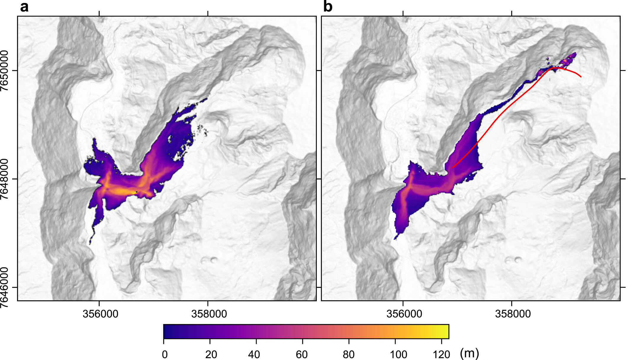
In May 1965, a main landslide occurred in a deeply incised valley of Piton de la Fournaise volcano, in Réunion Island. This event occurred one day after heavy rainfalls and was consequently interpreted as a mud/debris flow. We take advantage of several sets of historical photographs to reappraise this event. They show that the collapse of a large part of the valley headwall produced a rock flow that dropped 1,740 m and traveled 5,050 m. The surface morphology suggests that the landslide produced a main flow that evolved in a secondary flow in the distal part. The main flow deposit is composed of a matrix-rich fragmented facies and a jigsaw-fracturated facies. The matrix presents a gravely-to-silty granulometry and fractal dimensions ranging between 2.472 and 2.865. Volumes of the collapsed material (59.7 ± 3.1 Mm3) and the deposit (46 ± 13 Mm3) were determined from a photogrammetric approach. We estimated velocities ranging between 86 and 44 m s−1 along the flow path. Our simulations with SHALTOP reveal that the landslide geometry and velocities are well reproduced with frictional Coulomb rheology. We thus interpret the 1965 Mahavel landslide as a main rock avalanche rather than a mud/debris flow. We propose that the trigger of the 1965 avalanche, and of the smaller events in 1995 and 2001, is the water infiltration related to the intense rainfalls, which systematically preceded by one day each collapse. Finally, the succession of dry and wet years before each collapse event could promote favorable conditions to failure.
DOI : https://doi.org/10.1016/j.epsl.2019.04.003.