Analysis of all the seismological, bathymetric, geodetic and geochemical data collected by the programme reveals a complex volcanic system, with no known analogue, that is rooted deep beneath the lithosphere, remobilising ancient and newly-formed regional tectonic structures to emit one of the largest volumes of lava onto the ocean floor in recent centuries.
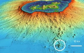
By comparing bathymetric data acquired in 2014 by the French Navy’s Hydrographic and Oceanographic Service (SHOM) and those from MAYOBS1, scientists have estimated that a volume of lava in excess of 5 km3 was released to form the new volcano. This eruption is by far the largest underwater eruption ever documented. It is comparable to the eruptions observed at the planet’s main hotspots, such as Hawaii and Iceland, although it is not located in the same geodynamic context. The presence of an acoustic plume and geochemical anomalies in the water column above the edifice confirmed that the eruption was in progress at the top of the volcano when the scientists arrived on site.
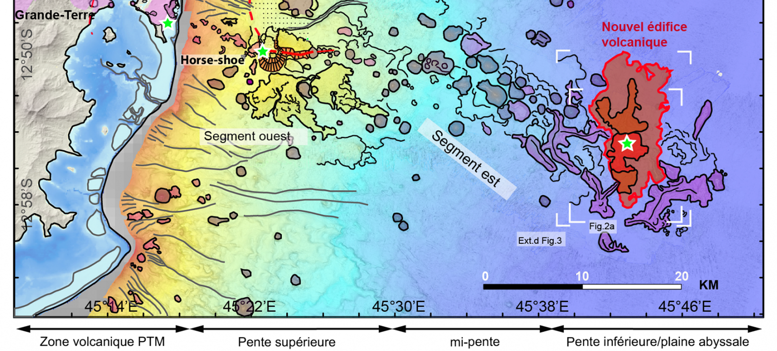
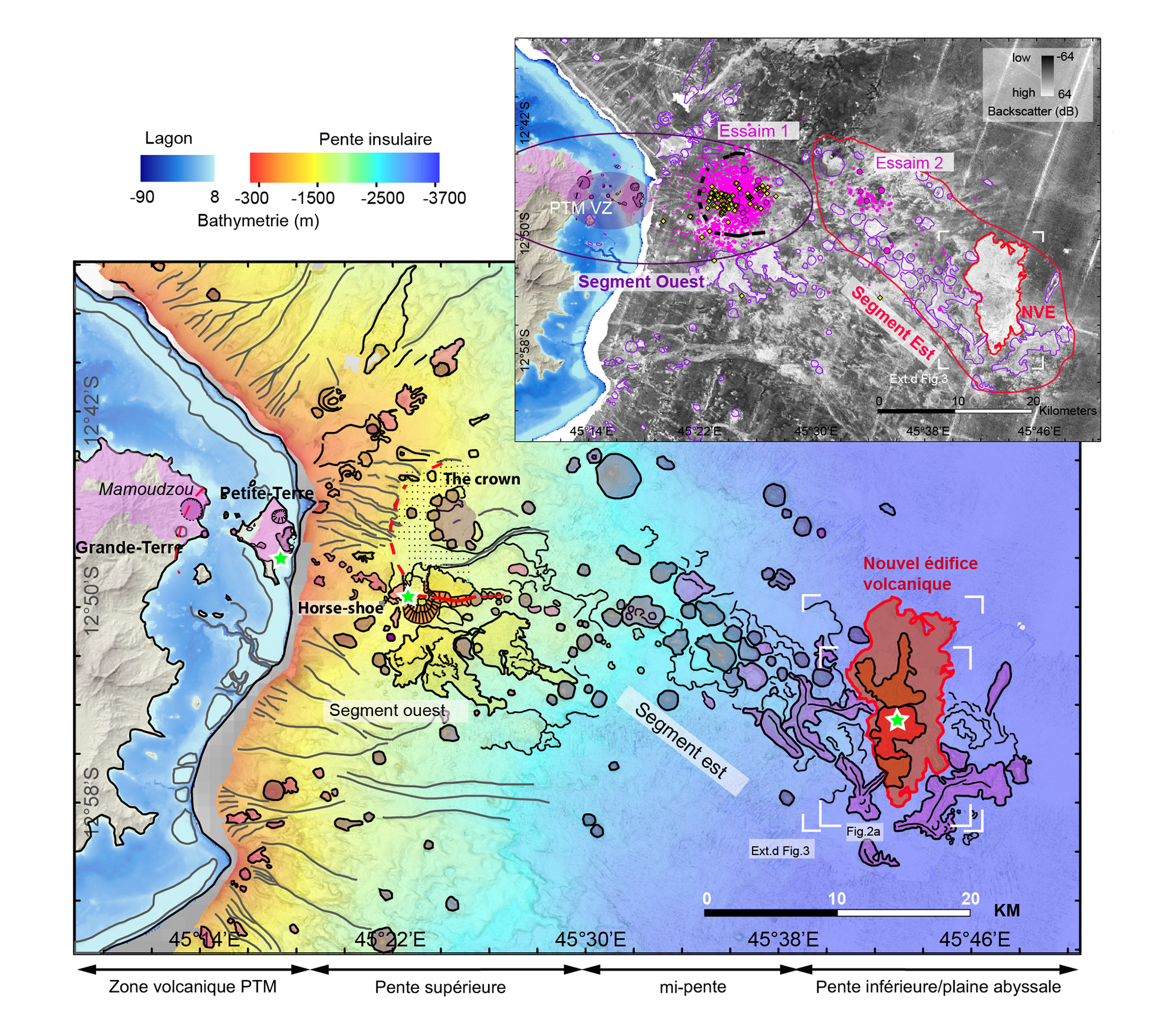
This new edifice is located at the end of a volcanic rift (named the Mayotte rift by the study) that extends to the east of the island of Mayotte over a length of around 50 km. This rift is made up of very well-preserved volcanic domes and lava flows that were probably formed during the Quaternary period (geological period between 2.5 million years ago and the present day). The land-based volcanic edifices on the island of Petite-Terre in Mayotte are several thousand years old and some of the structures are reminiscent of an ancient submarine caldera 8 km in diameter, between 5 and 10 km east of the coast of Petite-Terre.
The study of seismicity, recorded by the network of seismometers on land and at sea, and precisely relocated using OBS, and the analysis of land and seabed geodesy data have enabled the authors of the study to propose a model of magmatic storage and drainage linked to the eruption.
The earthquakes are much deeper than is usually observed in volcanic contexts and are located below the boundary between the Earth’s crust and mantle (or Moho). They highlight the existence of very deep reservoirs and drainage systems spread throughout the thickness of the lithosphere, something that has never before been clearly observed in volcanology.
Geodetic data show that the island of Mayotte is subsiding and moving eastwards at exceptional speeds. Models indicate that these deformations are linked to the emptying of one or more very deep magma reservoirs in the Earth’s mantle. The study suggests that the main reservoir is located near the island of Petite-Terre, beneath the old caldera. This caldera structure would therefore be the deepest ever documented (55 km). The magma would have drained from this main reservoir via a vein (or dyke) to a second, more superficial reservoir and then to the surface along the Mayotte volcanic rift.
This volcanic rift is a volcano-tectonic structure similar to other rifts documented in the Comoros archipelago. These volcano-tectonic structures are either neo-formed or result from the reactivation of old transform faults dating from the opening of the Mozambique Channel. They are organised in echelons along the Comoros archipelago to accommodate active tectonic deformations in a transfer zone between the submarine part of the East African rift and the Malagasy rifts. Between these stepped structures, zones of damage would be ideal sites for magma storage and the formation of large magma reservoirs. Volcanic activity in Mayotte, as in many other regions of the world, is therefore controlled by regional tectonics.
Since the MAYOBS1 campaign and the creation of REVOSIMA (Réseau de surveillance volcanologique et sismologique de Mayotte), many other campaigns at sea have taken place in the area to monitor eruption, seismicity and associated deformation. These campaigns continue to provide invaluable data for monitoring and refining our understanding of this complex and unprecedented volcano-tectonic system.
Réf : Feuillet, N., Jorry, S., Crawford, W.C. et al. Birth of a large volcanic edifice offshore Mayotte via lithosphere-scale dyke intrusion. Nat. Geosci. (2021). https://doi.org/10.1038/s41561-021-00809-x
For more information: see the Mayotte volcanological and seismological monitoring network website