Citizen / General public
Researcher
Student / Future student
Company
Public partner
Journalist
Teacher / Pupil

Ecuador subduction ” supercyclic ” behavior highlighted after the Pedernales earthquake of April 16th, 2016

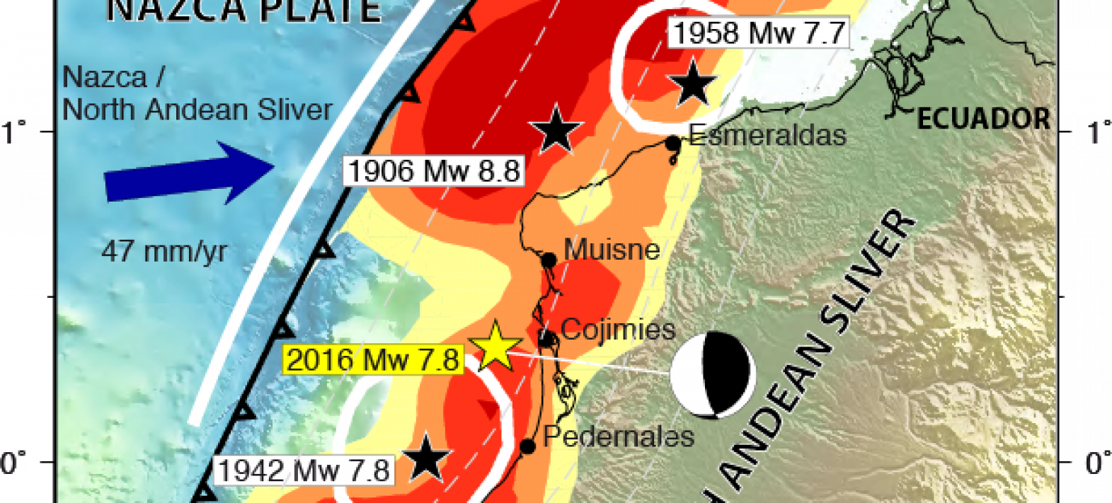
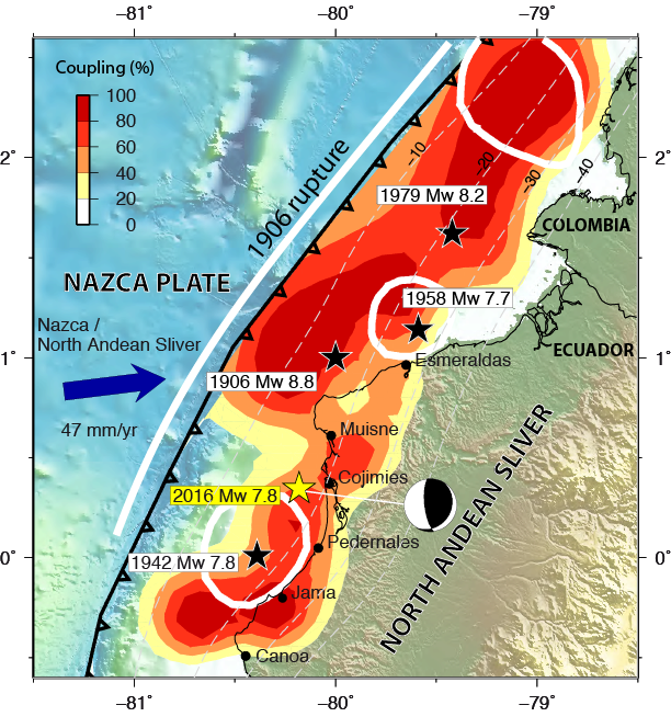
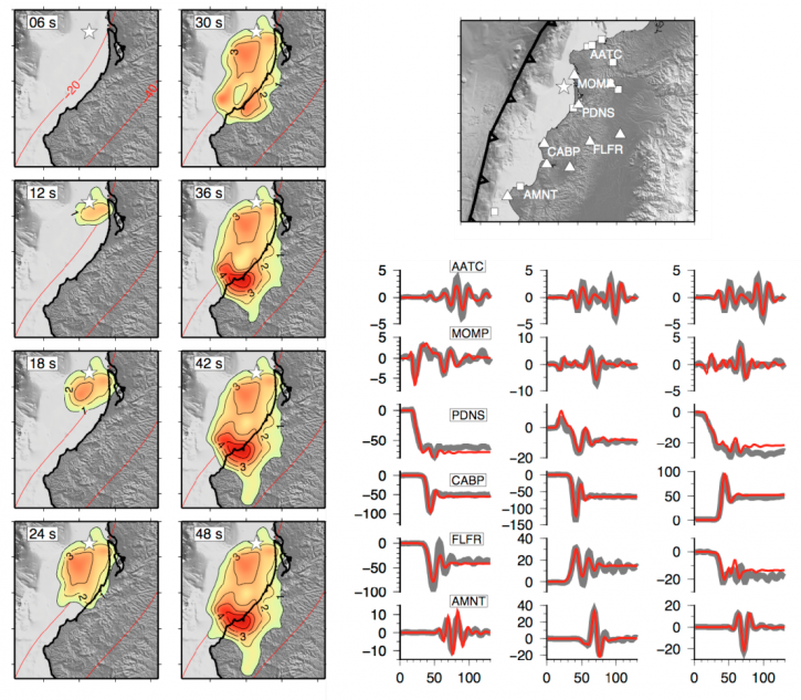
The Pedernales earthquake (magnitude 7.8) violently struck Ecuador's central coast on April 16, 2016, causing nearly 700 casualties and more than 16,000 injuries.

Ecuador subduction ” supercyclic ” behavior highlighted after the Pedernales earthquake of April 16th, 2016

Publication date: 09/01/2017

Research

Related themes : Natural Hazards

This earthquake is a continuation of the intense seismic activity in this area during the 20th century (earthquake of magnitude ~8.6 in 1906, followed by earthquakes of magnitude 7.7-8.2 in 1942, 1958 and 1979, see Figure 1). Based on this past seismicity, various projects have been set up since 2007 in collaboration with the Institute of Geophysics in Quito, to develop our capacity to observe earth deformations in this area, by installing GPS, seismometers and accelerometers. Initially instigated by the Geoazur laboratory, these projects have since been extended to the wider French community (IPGP, ISTEP) and have benefited from the ongoing involvement of the IRD and the support of the ANR.

These field observations, supplemented by satellite interferometry techniques (InSAR) and global seismic recordings (by the GEOSCOPE network, among others), have enabled us to reconstruct the earthquake rupture process in detail. As shown in Figure 2, the rupture lasted 45s and propagated from north to south over a distance of 100km, successively rupturing two zones along the Ecuadorian coast at a depth of between 15 and 30km. The second zone is characterised by a strong slide of 6 metres over an area of 30×30 km2 at a depth of 20 km below the coast. The associated sharp drop in stress led to very high ground accelerations (1.4 times the value of the gravity field). The preferential direction of the rupture also created a strong amplification of the seismic waves for the zones located to the south of the rupture (directivity effect). This effect explains at least in part the severe damage observed in the towns of Portoviejo and Manta, while the towns to the north of the rupture (Esmeraldas) were little affected.

Figure 1: Major earthquakes in the Ecuador subduction zone since 1906. The white outlines indicate the zones of past ruptures, while the colours represent the coupling of the subduction interface (determined by GPS), a strong coupling corresponding to significant seismic potential. The epicentre of the Pedernales earthquake is indicated by the yellow star.
Figure 2: Rupture process of the Pedernales earthquake. On the left, snapshots of the rupture progression, showing the slip (in metres) that accumulates every 6 seconds. Right: illustration of some of the stations used to analyse the earthquake rupture. The displacements observed, in black (in cm as a function of time in seconds), are modelled by the synthetics in red. The three components of each observation point (East on the left, North in the middle, and vertical on the right) are represented.

As well as being useful for analysing the earthquake itself, the GPS data can be used to determine the stresses that accumulate along the Equator subduction line year after year. These measurements reveal that the displacements induced by the earthquakes of 1942, 1958, 1979 and 2016 are greater than the potential accumulated by the movement of tectonic plates since 1906. In other words, the high recurrence of major earthquakes since 1906 corresponds to the release of forces accumulated over several centuries. Recent marine palaeoseismology data acquired during an offshore campaign in 2000 on the Ecuadorian margin (Migeon et al., 2016) confirm a long period of seismic silence before the 20th century and a similar sequence at the end of the Middle Ages. The North-Ecuador and South-Colombia subduction therefore seems to follow a behaviour known as an earthquake ‘supercycle’, already observed for continental faults and the Sumatra subduction. In this behaviour, long periods of energy accumulation are followed by successive large earthquakes, each releasing only part of the accumulated energy. This behaviour makes it very difficult to understand the risk of earthquakes, and means that we should not always follow the intuitive but over-optimistic idea that a major earthquake reduces the risk of earthquakes.

Find out more:

Latest news
A new tectonic micro-plate identified north of the Dead Sea Fault
In a study published in Science Advances, an international team has systematically analysed Sentinels-2 radar images to identify a new tectonic micro-...
Yann Klinger awarded ERC Advanced Grant 2023
Yann Klinger, CNRS Research Director and head of the Tectonics and Mechanics of the Lithosphere team at the IPGP, has been awarded the prestigious Eur...
Meteorites and magnetism in comics!
To make it easier to communicate her research subject, a researcher from the IPGP and MIT has teamed up with an illustrator, herself a geophysicist, t...
The NanoMagSat mission gets go-ahead from ESA!
The Programme Board for Earth Observation of the European Space Agency (ESA) has just decided to proceed with the NanoMagSat mission. This mission, in...