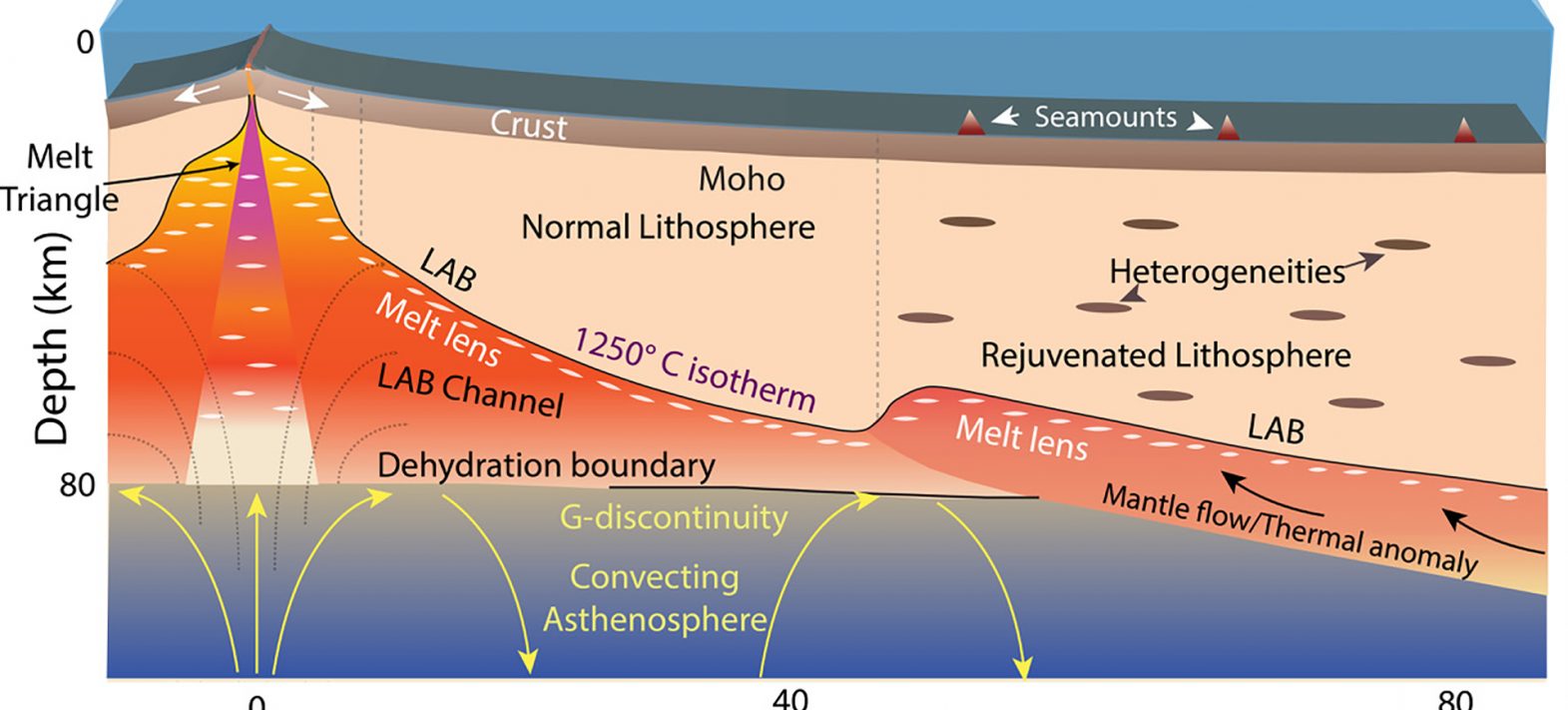
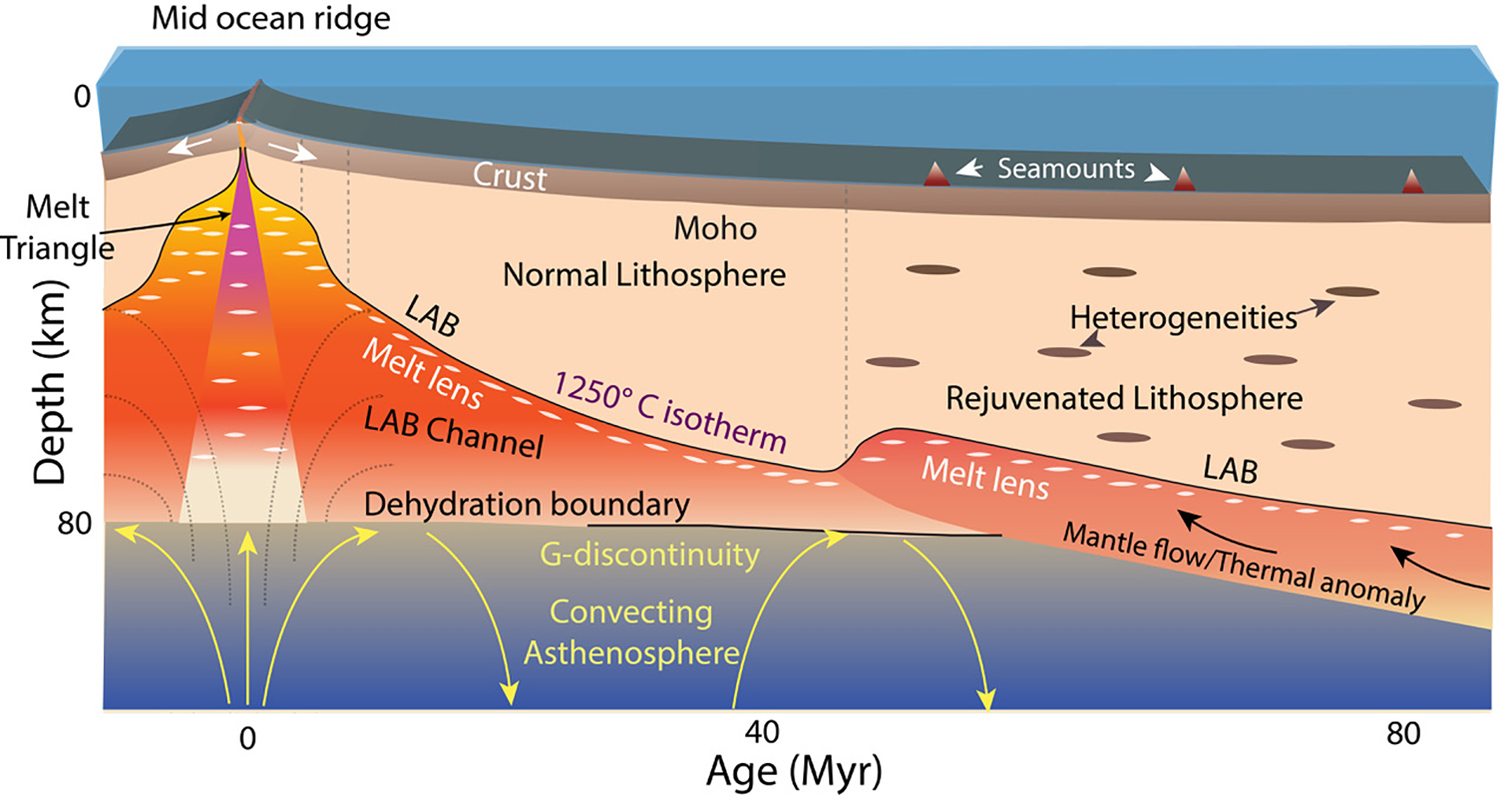
The Earth is the only planet in the solar system whose surface is divided into different plates, commonly referred to as the lithosphere. The concept of plate tectonics is based on the existence of a solid, rigid lithosphere moving over a deformable asthenosphere; volcanoes and earthquakes being the most visible manifestations marking the boundaries between these plates. At ridges, where oceanic crust is formed by upwelling and melting of the mantle, the lithosphere is thin, but as the plate moves away from the ridge, the lithosphere cools and thickens, marking the separation from the asthenosphere.
Located several tens of kilometers below the surface, the study of this boundary, fundamental to understanding the formation and evolution of the lithosphere and, more broadly, the dynamics of plate tectonics, remained a subject of debate. Indeed, traditional seismological imaging techniques offered too low a resolution to accurately image the base of the lithosphere, and could even lead to contradictory results depending on the methods used or in relation to certain models. Some results indicate that the lithosphere thickens over time, while others indicate that the lithosphere lies at a constant depth of around 70 km, producing contradictory models of the lithosphere-asthenosphere boundary. Some studies suggest, for example, that the lithosphere-asthenosphere boundary corresponds to the Gutenberg discontinuity, defined by Beno Gutenberg in the early 20th century, located at a depth of 70 to 80 km.
In 2015, with funding from the European Research Council (ERC), researchers from the Institut de Physique du Globe de Paris (IPGP/Université Paris Cité/CNRS) conducted a campaign aboard WesternGeco’s oceanographic vessel Trident in the equatorial Atlantic Ocean. Using industry-leading technology, they acquired 1,400 km of seismic reflection profiles covering an area of oceanic lithosphere between 2 and 75 million years old. A powerful source of sound energy was used to probe the depths of the earth, with this emitted signal reflecting off the various layers at depth, forming, in return, an image of the internal structure beneath the surface. This return signal was recorded using a 12 km-long cable, called a marine flute, on which sensors were placed every 3.125 meters. With the ship moving at a speed of around 7 km/h, seismic data was recorded every 75 m, enabling deep-earth structures to be imaged with unprecedented resolution, at intervals of 6.25 m continuously along the 1,400 km profile.
The authors of the study, published this June 17th, 2022 in the journal Science Advances, discovered two distinct reflections in the Earth’s mantle: a lithosphere-asthenosphere boundary that deepens with the age of the lithosphere, and a Gutenberg discontinuity that remains constant at a depth of 75 km.
These results suggest, on the one hand, that the lithosphere-asthenosphere boundary does indeed resemble a solid-melt boundary corresponding to a temperature of ~1250°C, where the solid lithosphere rests on lenses of water-rich magma. And secondly, that the Gutenberg discontinuity is a boundary that forms at the ridge dividing the water-rich mantle from the water-poor mantle, and remains stable over time.
The data collected during this oceanographic campaign also indicate that the passage or presence of a hot spot, which rises from the mantle, can have a rejuvenating effect on the lithosphere, lifting the lithosphere-asthenosphere boundary and destroying the Gutenberg discontinuity.
Réf : Audhkhasi, P. and Singh, S. C. Discovery of distinct Lithosphere Asthenosphere Boundary and the Gutenberg Discontinuity in the Atlantic Ocean, Science Advances, 8, eabn5404, June 17, 2022. DOI:10.1126/sciadv.abn5404