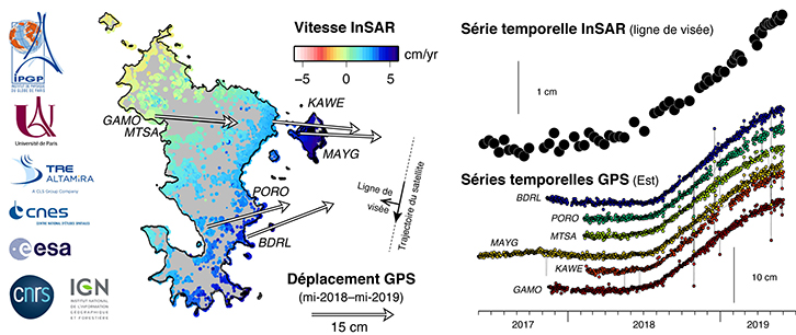
At the request of the Institut de Physique du Globe de Paris (IPGP) and with the support of the Centre National d’Etudes Spatiales (CNES), TRE ALTAMIRA, a subsidiary of the CLS Group (Collecte Localisation Satellite) with expertise in radar interferometry, has mapped the deformations affecting the island of Mayotte using around fifty images acquired since 2017 by the European Union’s Sentinel-1 radar satellites, developed and operated by the European Space Agency (ESA)4. These satellites record the distance travelled by the radar signal between transmission and reception with a high degree of accuracy. By comparing changes in this distance over time, radar interferometry technology provides highly accurate information on ground deformation, enabling movements to be detected with millimetre precision. The SqueeSAR® algorithm, developed and patented by TRE ALTAMIRA, identifies ground targets or “Persistent Scatterers” for which it will be possible to assess displacement. This method makes it possible to map in time and space the deformations affecting the whole island (Illustration 1). The start of deformation in mid-2018 and the gradual tilting of the island are precisely measured, providing additional information that is denser than that provided by the GPS network.
These data are currently being analysed by IPGP researchers, with the aim of gaining a better understanding of the source of these deformations and thus better assessing the hazards associated with the current crisis.
This study is part of the REVOSIMA (RÉseau VOlcanologique et SIsmologique de Mayotte de l’IPGP) programme. It is supported by the Centre national d’études spatiales (CNES), the Institut national des sciences de l’univers du Centre national pour la recherche scientifique (CNRS-INSU), the ForM@Ter solid earth cluster and the Délégation interministérielle aux risques d’Outre-Mer. The InSAR processing of Sentinel-1 data was carried out by TRE ALTAMIRA, a CLS Group subsidiary, using its own funds; the SqueeSAR® results were made available to the IPGP and the CNES.
Find out more about monitoring seismo-volcanic activity in Mayotte
In order to shed light on the mechanisms behind the earthquakes felt since May 2018 in Mayotte, as well as other geological phenomena observed in the area, observation and research operations, carried out by several French research establishments (IPGP/CNRS/BRGM/Ifremer) as part of the Tellus- Mayotte programme (CNRS-INSU) funded by the Ministry of Higher Education, Research and Innovation and the Ministry of Ecological and Solidarity Transition, were launched in autumn 2018.
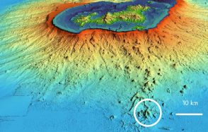
It was these operations that led to the discovery, at the end of May 2019, of a new active underwater volcanic edifice off Mayotte. Following this discovery and in order to organise the scientific and operational response to this large-scale geological phenomenon close to Mayotte and thus enable it to be better understood and managed, the “Réseau de surveillance volcanologique et sismologique de Mayotte” (REVOSIMA), the structure in charge of monitoring volcanic and seismic activity in the Mayotte region, was set up in summer 2019.
The IPGP’s RÉseau de surveillance VOlcanologique et SIsmologique de MAyotte (REVOSIMA) is based on onshore measurement stations (BRGM, IPGP, IPGS, IGN and collaborators) and oceanographic campaigns (IFREMER, IPGP, BRGM and collaborators). This network is operated by the IPGP with the support of BRGM and is under the responsibility of the Piton de la Fournaise volcanological observatory (OVPF-IPGP) and BRGM’s regional office in Mayotte. The data for this monitoring network is produced by a large consortium of French scientific partners (IFREMER, CNRS, IPGP, BRGM, IPGS, IGN, ENS, SHOM, Météo France, CNES, ISTerre, UCA, Université de La Réunion, IRD) and funded by the French government (Ministry for Higher Education, Research and Innovation, Ministry for the Ecological Transition and Solidarity, Ministry of the Interior, Ministry for Overseas France). Seismic and GNSS data are distributed by IPGP(http://volobsis.ipgp.fr/), RESIF, RENASS, RGP and are supported by the Service national d’observation en volcanologie (SNOV-INSU). www.ipggp.fr/revosima
The GNSS data used in this study are the property of CNES (MAYG station), EXAGONE via the TERIA network (BDRL and GAMO stations) and Précision Topo via the Lel@ network (KAWE, PORO, MTSA). All the GNSS data has been processed and is supplied by the Institut national de l’information géographique et forestière (IGN) via the RGP (rgp.ign.fr). The CNRS-INSU is funding the IGN in its efforts to coordinate geodetic operations to monitor the seismo-volcanic crisis in Mayotte(http://mayotte.gnss.fr/ andftp://rgpdata.ign.fr/pub/gnss_mayotte/).
Sentinel-1 data comes from the European Union’s Copernicus programme for Earth observation and monitoring, coordinated by the European Commission. The satellite products are generated by the European Space Agency (ESA) and distributed via the CNES PEPS site (Plateforme d’Exploitation des Produits Sentinel, https://peps.cnes.fr).