Citizen / General public
Researcher
Student / Future student
Company
Public partner
Journalist
Teacher / Pupil

Real-time imaging of a volcano’s internal plumbing to better anticipate eruptions

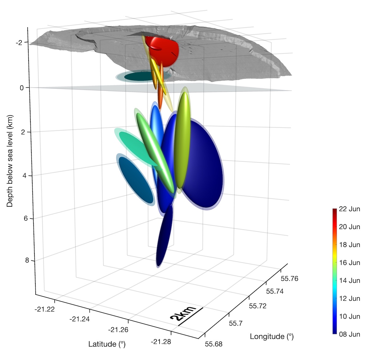
Researchers at IPGP and their international colleagues have developed a new operational method for monitoring volcanoes: using GPS measurements to track, in real time, the internal structures stressed by magma overpressure as it migrates towards the surface. This technique, known as "mechanical tomography", has been implemented at Piton de la Fournaise on Reunion Island.

Real-time imaging of a volcano’s internal plumbing to better anticipate eruptions

Publication date: 15/10/2020

Observatories, Press, Research

Related themes : Natural Hazards

Internal plumbing “lit up” from the inside

During the preparatory phase of an eruption, a volcano deforms slightly due to the movement of magmatic fluids at depth. Modelling these surface deformations makes it possible to determine and quantify some of the characteristics of the active source that causes them: its location, geometric shape and variation in volume. However, the term ‘tomography’ (which comes from the Greek root ‘representation in sections’) had never been used in volcanology to describe the image obtained from active deformations, even though this method is entirely complementary to other structural imaging techniques (seismic, electrical, gravimetric, etc.).

In a study published in Geophysical Research Letters, researchers from the Institut de Physique du Globe de Paris (IPGP-Université de Paris), the ISTerre (IRD, Université Grenoble-Alpes), the Laboratoire de Biométrie et Biologie Évolutive (LBBE-CNRS-Université Claude Bernard Lyon I) and Gadjah Mada University (Indonesia) have demonstrated that, from an inversion of a map of the Earth’s crust, the deformation of the Earth’s crust can be measured, that, using Bayesian inversion and a relatively simple analytical model, it is possible to obtain a coherent image of a volcano’s internal plumbing from real-time GPS measurements, with each structure used and subjected to magma pressure being activated as it migrates towards the surface.

A revolutionary analytical model

The analytical model used in this study, called the Point Compound Dislocation Model (pCDM), was recently proposed by Nikkhoo et al. (2017). It can simulate any form of source (sphere, ellipsoid, sill, dyke, pipe) in a homogeneous elastic medium and in the far field, with a limited number of parameters. This means that it can replace most of the previous analytical models, which had to be used on a case-by-case basis.

Following the most optimised numerical coding possible of the model’s equations (in C and Matlab languages), the research team implemented the model in an inverse problem adapted to explore the ‘model space’, i.e. the set of probable solutions, through millions of calculations in just a few tens of seconds. The method used is called ‘unsupervised’ because it minimises the amount of a priori information imposed on the calculation: it is the model that determines the set of most probable source locations and shapes, constrained exclusively by the observed GPS measurements and their uncertainties. The result is an advanced and perfectly quantified ‘translation’ of the surface data.

Spatio-temporal structures obtained at Piton de la Fournaise during the magma migration phase prior to the eruption of June 20, 2014 (© Beauducel et al. 2020)

Application to Piton de la Fournaise

The method has been implemented as a new WebObs module, an open-source system created at the IPGP that makes it easy to develop and test real-time monitoring tools. A minor eruption of Piton de la Fournaise in June 2014, for which less than 1 cm of pre-eruptive deformation was observed, at the limit of instrumental sensitivity, was used to validate the method. The model clearly showed the magma’s upward migration during the ten days preceding the eruption, before converging towards superficial sources with geometries compatible with the other observations (seismic in particular). The latest volumes obtained, around 300,000 m3, are in line with the volume of lava actually emitted at the surface.

This scientific success is therefore crucial for predicting eruptions: pre-eruptive deformation models are now able to give a consistent estimate of the variation in volume generated by the magma, which can be interpreted, under certain conditions, as an indicator of the volume of lava to come. Now routinely used at the Piton de la Fournaise volcanological observatory, this method has been used to visualise magma migration over the four days preceding the last magmatic intrusion on 28 and 29 September 2020.

Ref:

Latest news
Jérôme Vergne becomes the new Director of the OVSM-IPGP
Committed to the various aspects of observing and monitoring telluric phenomena, Jérôme Vergne joined the IPGP on 1 July 2024 as Director of the Volca...
Evidence of magmatically induced faults at the East Pacific Rise
By comparison of ultra-high-resolution 3-D seismic imagery and bathymetry data collected at the East Pacific Rise (EPR) 9º50'N, researchers reveal the...
Charles Le Losq appointed member of the Institut Universitaire de France
The role of the Institut Universitaire de France (IUF) is to encourage the development of high-level research in universities and to strengthen interd...
NASA will measure earthquakes on the Moon using technologies developed for the InSight mission on Mars
The technology of the two seismometers that are part of NASA's Farside Seismic Suite instrument has detected more than a thousand earthquakes on the R...