Citizen / General public
Researcher
Student / Future student
Company
Public partner
Journalist
Teacher / Pupil

A better anticipation of tsunamis thanks to GPS satellites

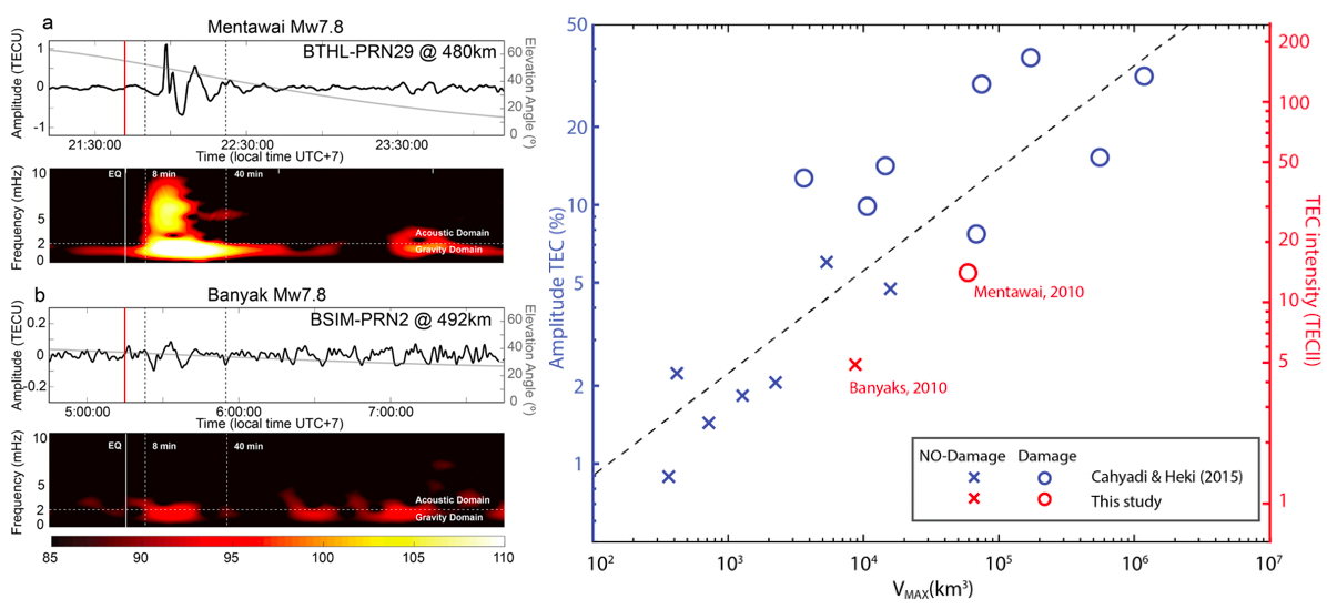
In a study published on July 6th in Nature - Scientific Reports, a team of researchers from the Institut de Physique du Globe de Paris (University of Paris, CNRS) and the Earth Observatory Singapore (EOS) propose a new technique for estimating the risk of an earthquake-generated tsunami by observing the movements of the upper atmosphere.

A better anticipation of tsunamis thanks to GPS satellites

Publication date: 10/07/2020

Press, Research

Related themes : Natural Hazards

When an earthquake occurs, the disturbances produced by the rupture of the earth’s crust propagate in all directions, including through the atmosphere to its highest layers, including the ionosphere. If this earthquake is underwater, the movement of the rupture of the ocean floor can trigger a tsunami. The largest tsunamis are generated by submarine ruptures in subduction zones. However, it has been observed that a rupture in the most superficial part of the subduction zone often produces a tsunami that is much larger than expected for the magnitude of the earthquake.
Described for the first time in 1972, these tsunami earthquakes (or “tsunami-earthquakes”) are earthquakes that generate a tsunami that far exceeds the estimate calculated using seismometer data. This type of tsunami is often underestimated by current tsunami warning systems, even though they are among the most deadly.

In this study, Fabio Manta and Giovanni Occhipinti, from the IPGP, and their colleagues from EOS, introduce a new technique capable of transforming the oscillations of the ionised layers of the upper atmosphere, detected by GPS satellite, into an estimate of the volume of water displaced during the genesis of a tsunami. In particular, they are studying two earthquakes of magnitude Mw 7.8 (one a tsunami earthquake and the other not) that occurred along the Sunda fault, off the coast of Sumatra. These two earthquakes were virtually identical and were estimated by conventional warning systems to pose no risk of tsunami, even though one of them generated a deadly tsunami that killed 400 people.
By applying their method to the data from these two earthquakes, the scientists have demonstrated for the first time that ionospheric observations from satellite positioning systems (or GNSS) can be used to assess the tsunamigenic potential of earthquakes as early as 8 minutes after the main tremor. They thus open up a new avenue for tsunami risk warning and estimation systems, exploiting the high density of GPS sensors already orbiting our planet.

This study is part of the IPGP’s work, supported by CNES, to explore new ways of probing the Earth’s atmosphere and increasing the number of observables capable of improving tsunami warning.

Left: the atmospheric signature of the two earthquakes is virtually identical, with the hat signal corresponding to the deadly tsunami. Right: the new method tested on 17 tsunamigenic events.

Ref: F. Manta, G. Occhipinti, L. Feng, E. M. Hill, Rapid identification of tsunamigenic earthquakes using GNSS ionospheric sounding, Scientific Report. https://www.nature.com/articles/s41598-020-68097-w

Latest news
Charles Le Losq appointed junior member of the Institut Universitaire de France
Congratulations to Charles Le Losq, associate professor in the Geomatériaux team, on his appointment as a junior member of the Institut Universitaire ...
The Science and Art of Paleoseismology : a collective work to enrich research and teaching
Paleoseismology aims to understand past earthquakes in order to better predict future ones. This discipline, which is based on the study of the trac...
Hera flies over Deimos on its way to Dimorphos : a major step forward for planetary protection
On 12 March 2025, the European Space Agency's (ESA) Hera probe flew past Mars and its natural satellite Deimos. The aim of this crucial manoeuvre was ...
IPGP supports the Stand Up For Science movement
Stand Up For Science: Mobilising for science and academic freedom. 7 March 2025, a day to defend scientific research and education