Citizen / General public
Researcher
Student / Future student
Company
Public partner
Journalist
Teacher / Pupil

Axial volcano in the Eastern Pacific: crustal formation by melt sill injection in a pile lava flows

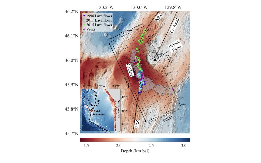
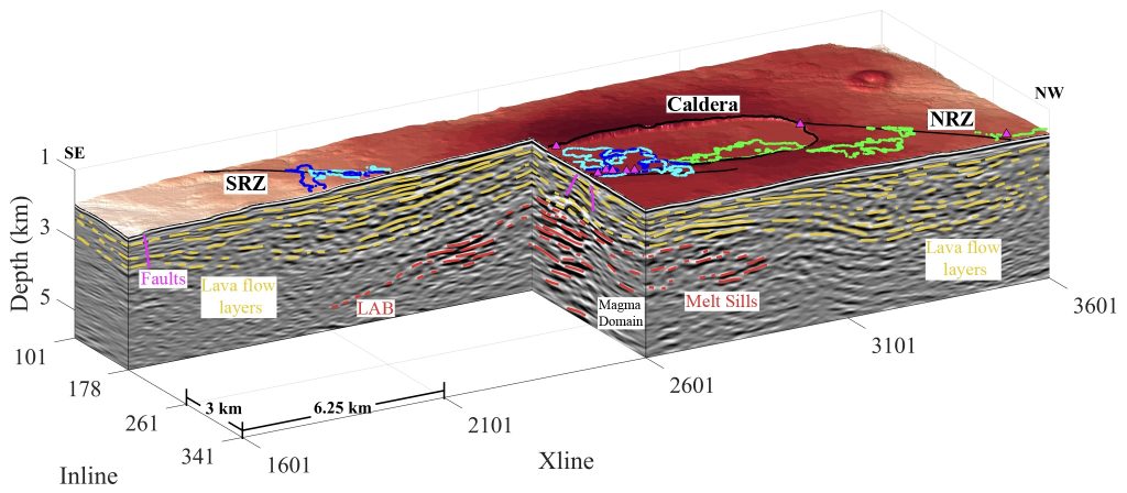
An institut de physique du globe de Paris (IPGP) team in partnership with United States colleagues have discovered that most of the upper crust at Axial volcano is formed by lateral injection of melt sills in a pile of lava flows from a large magma reservoir underneath. Their work, published in Nature Communications on March 5, 2026, opens a new perspective on ‘how large volcanic islands, such as Iceland, are formed’.

Axial volcano in the Eastern Pacific: crustal formation by melt sill injection in a pile lava flows

Bathymetry of Axial Seamount / NOAA, Public domain, via Wikimedia Commons

Publication date: 12/03/2026

Research

We are used to observed red lava flows at large volcanos, such as Etna, Hawaii, Iceland, extending tens of kilometres laterally from the crater of the volcano. These lavas are first stored in a sub-surface magma reservoir which cuts through the crust and reaches the surface through thin dikes before the eruption and therefore, it has been believed that the upper crust is formed by these surface sub-horizontal lava flows and the vertical dikes. Using 3D seismic imaging technique, the team has discovered that the lava flow deposited on the surface subside down to the large sub-surface magma reservoir and are injected by molten melt sills along the lava flow layer, and that the vertical dike layers are absent, suggesting that the upper crust in these environment are formed by lava flow – melt sill interaction. As the water rich lava flows interact with the magma in the reservoir, it gets remelted and erupts again on the surface and flows over a long distance.

The 3D seismic reflection data were acquired in 2019 on board the United States marine seismic vessel, R/V Marcus Langseth, at the Axial volcano in the eastern Pacific Ocean. Axial volcano, which sits at the intersection of the intermediate-spreading Juan de Fuca Ridge and Cobb hotspot, has a flat-topped summit with a horseshoe-shaped 8 km x 3 km caldera lying at about 1.4 km water depth (Figure 1). It hosts several hydrothermal fields and has been the site of three eruptions in the last decades, in 1998, 2011 and 2015, and the next one is imminent. During the 2019 marine survey, the Langseth was equipped with four 6-km long streamers spaced at 150 m and two sound sources spaced at 75 m, acquiring a 300-m wide swath at each vessel pass. The total survey area is 40 km by 16 km.

The processed 3D seismic reflection volume shows the presence of lava flow layers (in yellow) from seafloor down to 4 km depth (Figure 2). These layers dip towards the magma domain containing melt sills (red), a large magma reservoir. The top of the magma reservoir defines the crustal lithosphere-asthenosphere boundary (LAB). The lava flow subsidence is caused by the deflation of the magma reservoir during large volcanic eruptions, and further piling of lava flows. The conventional dike sequence is absent, instead molten melt sills are injected along the beddings of lava flow. Moreover, the lava flow layers, which are once formed at the seafloor, are in direct contact with the hot magma reservoir. As these lava flows layer contain water, they get easily remelted and mixed with the melt in the magma reservoir, changing the chemistry and viscosity of the erupted lavas.

This study at Axial volcano opens new perspectives on the dynamics of crustal magma reservoirs, its interaction with crustal rocks and volcanic eruption and could help to better understand other volcanic systems, such as Iceland. The experiment was funded by United States National Science Foundation, but the research was carried out at IPG Paris with partial support from the European Research Council.

The Axial Volcano in the NE Pacific showing the north rift zone (NRZ), south rift zone (SRZ), hydrothermal vents (magenta filled triangles) and the lava flows from the last three eruptions in 1998 (blue), 2011 (cyan) and 2015 (green)2. The horseshoe-shaped caldera, 8 km × 3 km, lies at the center of the volcano. The transparent grey shaded regions indicate the lithosphere-asthenosphere boundary (LAB) (Kent et al. 2025). The thick dashed rectangle indicates the area of the 3D seismic reflection box and thin dashed lines mark the inline and crossline numbers. The Inline numbers range from 101 to 538 spaced at 37.5 m and the cross lines (Xlines) range from 1001 to 4200 spaced at 12.5 m, giving rise to a 16.3 km × 40 km 3D box. Inset map shows the Northeast Pacific region. The star shows the location of Axial Volcano.
Figure 2. Lava flow layers in the 3D seismic data volume showing seismic reflection images crossing the south rift zone (SRZ), north rift zone (NRZ), and the south end of the summit caldera. Interpreted lava flow layers are highlighted using yellow lines, magma domain sills (below the LAB) are marked as red lines, and faults are shown as magenta lines. Locations of hydrothermal fields are shown as small, magenta-filled triangles. Outlines of the 1998 (blue), 2011 (cyan) and 2015 (green) eruption lava flows are overlain on the bathymetric map.

Source

Wu, H., Xie., W., Singh, S. C., Carton, H., Kent, G., Arnulf, A., & Harding, A. J. (2026). Oceanic crustal accretion by melt sill and lava flow interaction at Axial volcan, Nature Communications, Vol. 17, 

https://www.nature.com/articles/s41467-026-70033-x

Latest news
MAJIS on board JUICE: a key instrument for exploring Jupiter’s icy moons
As part of the team involved in the development and validation of the MAJIS instrument, the Paris Institute of Earth Physics is contributing to the sc...
Frédéric Moynier elected member of the Academia Europaea
Frédéric Moynier, professor at the Institut de physique du globe de Paris (IPGP) and Université Paris Cité, and Deputy Director for Research at IPGP, ...
Can we listen to Titan’s heartbeat?  Icequakes as a window into a hidden ocean.
Can we listen to Titan’s heartbeat? Icequakes as a window into a hidden ocean.
What lies beneath the surface of Titan, Saturn’s largest moon? This question is central to the upcoming Dragonfly mission, which will deploy a drone e...
Lithium isotopes unveil the hidden chemistry of Guadeloupe's volcanic waters
IPGP researchers present the first systematic lithium isotope survey of Guadeloupe's surface waters, revealing that a single small island can host a r...