Citizen / General public
Researcher
Student / Future student
Company
Public partner
Journalist
Teacher / Pupil

Earthquakes and volcanoes in Mayotte: conclusions of the last two sea campaigns

The MAYOBS 3 and 4 campaigns identified a new lava flow and produced the first images of the seabed. Meetings and debriefings with the various stakeholders in Mayotte also took place on board the Marion Dufresne.
Earthquakes and volcanoes in Mayotte: conclusions of the last two sea campaigns

Publication date: 02/08/2019

Observatories, Press, Research

Related themes : Natural Hazards

The last two oceanographic campaigns, “MAYOBS3” and “MAYOBS4”, funded as part of a knowledge acquisition programme by the Ministry of Ecological Transition and Solidarity and the Ministry of Higher Education, Research and Innovation, came to an end on Wednesday July 31st. To mark the occasion, a scientific presentation took place on board the oceanographic vessel Marion Dufresne, organised in two stages: firstly, a morning discussion between the scientists and the various stakeholders in Mayotte (members of parliament, elected representatives from the Departmental Council, mayors, experts, members of the pre-selection committee for the volcano’s name); secondly, a press conference in the afternoon.

These meetings were part of the government’s drive to ensure the transparent dissemination of scientific knowledge and to promote understanding of the phenomenon by enabling the public to take ownership of it. They provided an opportunity to showcase the data collected during the MAYOBS campaigns and to explain the collective work carried out by scientists from the French Research Institute for Exploitation of the Sea (Ifremer), the Geological and Mining Research Bureau (BRGM), the National Centre for Scientific Research (CNRS), the French National Institute for Geophysical Research (CNRS), the French National Institute for Geophysical Research (CNRS), the French National Institute for Geophysical Research (CNRS) and the French National Institute for Geophysical Research (CNRS), Centre National de la Recherche Scientifique (CNRS), Institut de Physique du Globe de Paris (IPGP) and Institut de Physique du Globe de Strasbourg (IPGS), Université de La Réunion and Université de Clermont Auvergne, under the direction of Nathalie Feuillet (IPGP), Yves Fouquet (Ifremer) and Isabelle Thinon (BRGM).

The aim of the MAYOBS3 mission was to recover some of the seabed seismometers that monitor the area, before they are redeployed in September 2019. The seismometers remaining on the seabed will enable monitoring to continue.

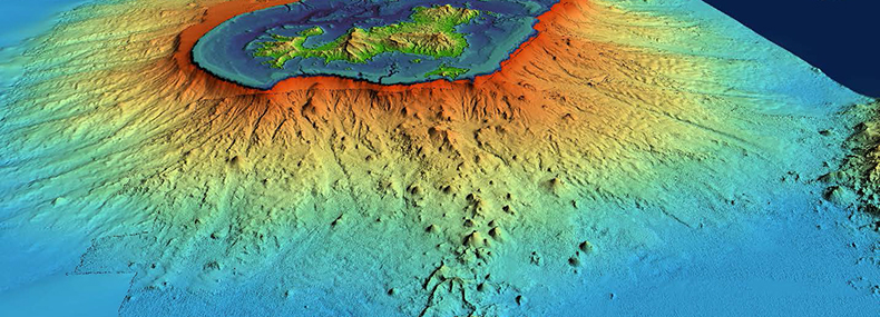
The MAYOBS3 and MAYOBS4 campaigns mapped the volcanic rift between the active volcano (around 50 km from the island) and the seismic zone (around 15 km from the island).
Seismicity has decreased. The earthquakes are deep (20 to 50 km). Deep earthquakes have also been located between the main seismic zone (15 km from the island) and the land. They have been present since the beginning, but were not located during previous missions because of their low magnitude (between 1 and 3).

A new flow identified

The data collected confirms that the height of the volcano has not changed (summit at a depth of 2850 metres). However, since June, a new volcanic flow has been identified on the western flank of the submarine volcano. It is more than 150 metres thick. The estimated volume is 0.3 km3.

The “MAYOBS3” and “MAYOBS4” campaigns also detected fluid emissions and plumes of volcanic origin. These plumes do not reach the surface. The plumes detected at the top of the new volcano in May and June no longer exist, while smaller plumes have been detected on the new flow.

The first images of the seabed

Two scampi dives (camera close to the bottom) were carried out on the volcano. They show pillow lavas and corded lavas typical of more fluid lavas. Fluid samples were taken from the plumes; analyses are currently underway.

Rock samples were taken from recent flows using four dredges.

The MAYOBS campaigns have therefore yielded a wealth of data. The scientific teams will continue to analyse this data on land to gain a better understanding of the potential risks associated with these seismic-volcanic phenomena.

For further information:

Latest news
Tribute to Gilbert Hammouya (1946-2025)
It is with great sadness that we learned of the passing of Gilbert Hammouya, former CNRS chemical engineer and iconic figure at the Guadeloupe Volcano...
Subscribe to
Subscribe to "Our Planet"
This MOOC proposed by a team from the Institut de Physique du Globe de Paris is aimed at anyone interested in Earth sciences and wishing to deepen the...
New Publication: Évolution(s). Science, art et littérature — A Unique Contribution from Nobuaki Fuji, Geophysicist at IPGP
The book Évolution(s). Science, art et littérature, published in May 2025 by Éditions Matériologiques, brings together contributions from 18 members o...
New insight into the origin of the Moon's depletion of volatile elements
The Moon's arid surface, devoid of liquid water and subject to extreme temperature variations, has long intrigued observers. These characteristics ind...