Citizen / General public
Researcher
Student / Future student
Company
Public partner
Journalist
Teacher / Pupil

Mudflows, Prêcheur river, Montagne Pelée, Martinique

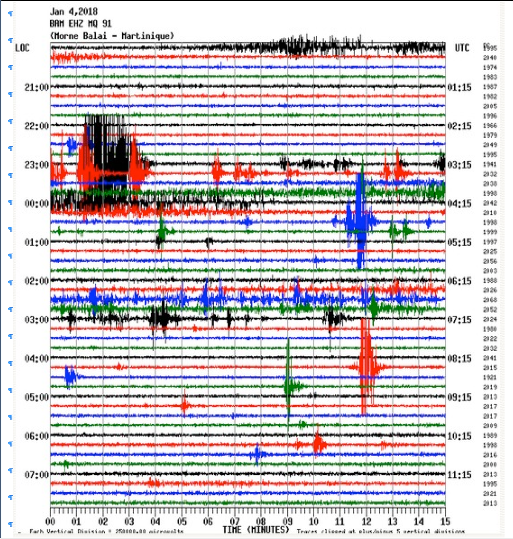
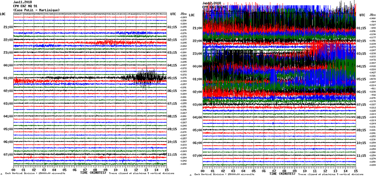
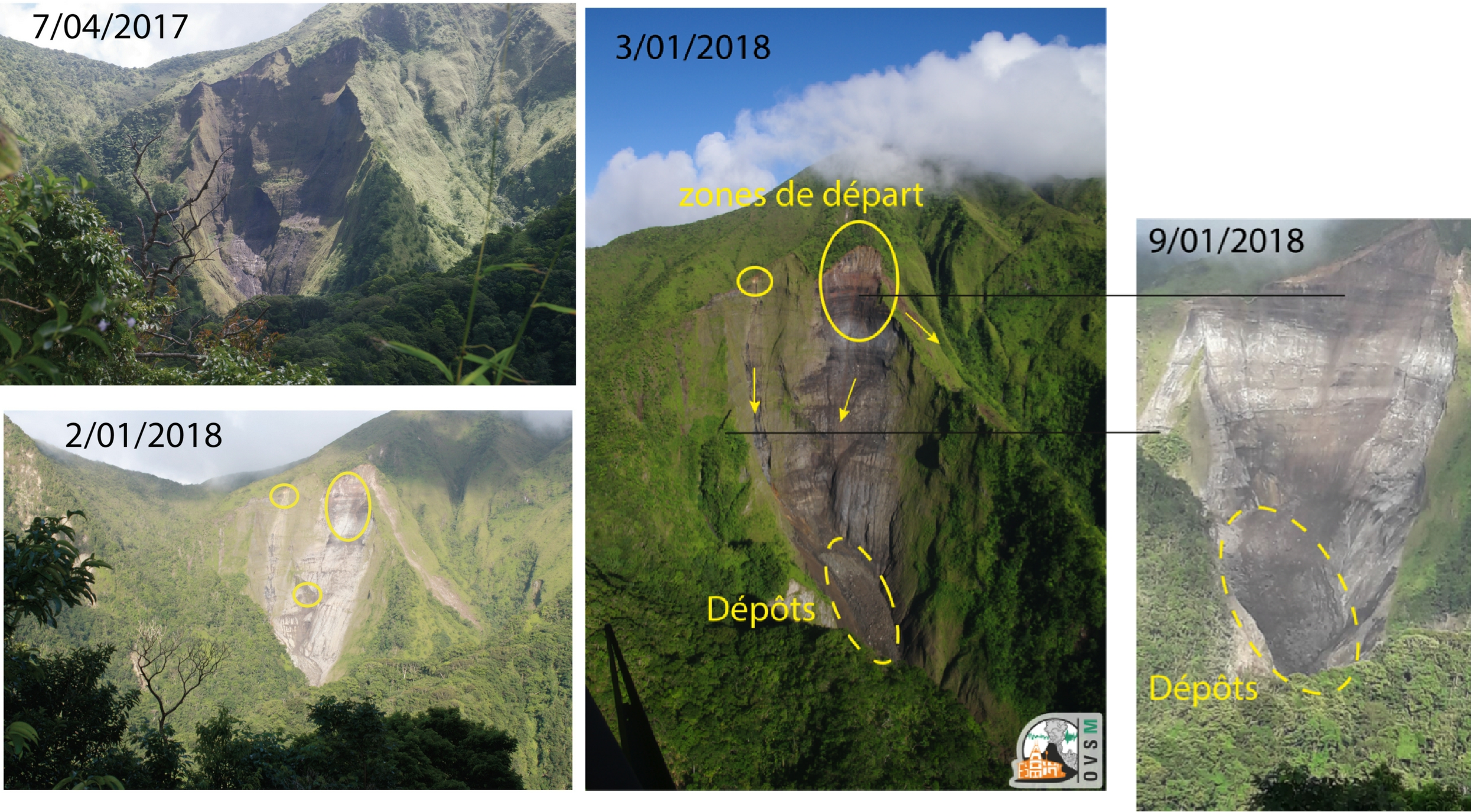
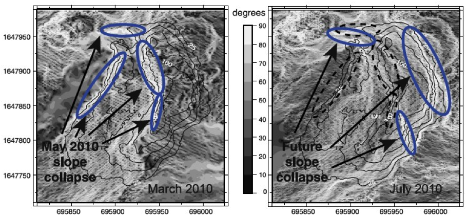
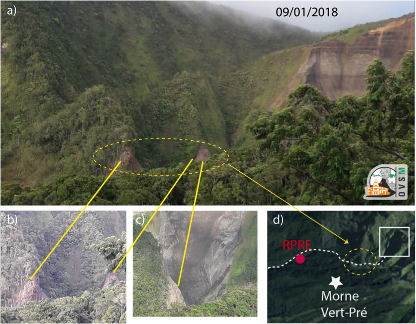
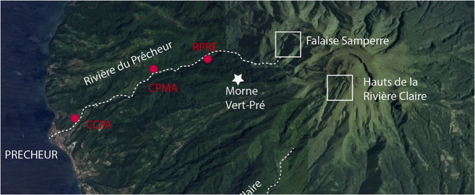
In Martinique, a major landslide sequence began on January 2nd 2018 at the Falaise Samperre, on the western flank of Montagne Pelée, north-west of the summit (Figure 1). It is still ongoing. The volumes involved in these landslides are greater than during the last major episode in April 2010.

Mudflows, Prêcheur river, Montagne Pelée, Martinique

Précheur River

Publication date: 12/01/2018

Observatories, Press, Research

Related themes : Natural Hazards

These landslides are in no way linked to any renewed volcanic activity on Montagne Pelée, which remains at a normal base level (green).

These landslides are recorded by the OVSM-IPGP seismological network and the strongest of them are heard or felt by the inhabitants of the Prêcheur commune. Several overflights of the Rivière du Prêcheur and the Falaise Samperre were carried out by the Civil Security Dragon 972 on January 3rd and January 10th. A drone overflight was carried out on 11 January at the request of DEAL Martinique.

The shallow gradient of the river limits the descent of landslide material downstream, and much of the landslide deposits accumulate at the foot of the cliff. In the event of heavy rain, some of these deposits are remobilised and spread into the Prêcheur river in the form of mudflows or lahars. These mudflows have considerably filled the downstream river bed, particularly at the level of the bridge in the town of Le Prêcheur, threatening the structure and overflowing into the neighbouring residential areas of Le Précheur.

Location of the points mentioned in this report and the acoustic recording systems on the Rivière du Prêcheurs (red dots). The flood detection station is located at RPRE. The white star at Morne Vert-Pré is the viewpoint from the Falaise.

Signal recording and detection by the Martinique Volcanological and Seismological Observatory

On January 2nd 2018, between 4am and 11am (local time), the OVSM-IPGP seismometers recorded an initial series of landslides that could be attributed to the Samperre cliff. After 48 hours of calm, new, larger landslides occurred on the night of January 3rd to 4th  (Figure 2a and 2b) and have been continuing ever since.

The volumes involved in these landslides are significant. Since January 6th  2018, 37 lahars have been recorded at the OVSM-IPGP, including 3 large ones on Saturday 6/01/2018 11:37, Sunday 7/01/2018 14:35 and Monday 8/01/2018 19:56 and a very large series of 17 successive lahars on the night of January 11th to 12th.

These lahars are associated with fairly intense rainfall episodes on the summit of Montagne Pelée. Further lahars of varying intensity will occur in the coming weeks, depending on rainfall. Their intensity cannot be predicted.

Recording of landslides on 4/02/2018. Each line corresponds to 15 minutes, the change of color allowing better legibility. Local time is shown on the left and UT time on the right. Data peaks correspond to successive shifts: the shift that occurred at 3:01 am (in black) is the largest. It was also recorded by seismological stations in the south of the island.
Records of the mudflows (lahar) of 11 and 12 January 2018. Each line corresponds to 15mn, the change of colour allowing a better readability. Local time is shown on the left and UT time on the right. The variations in signal amplitude correspond to the successive lahars.
Evolution of the Falaise Samperre between April 2017 and between 3/01/2018 and 9/01/2018. The middle shot was taken on 3/01/2018 during the helicopter flyover. The right-hand shot was taken on 9/01/2018 from Morne Vert-Pré. The cliff is approximately 300m high and 220m wide. These photos show that the most significant recent landslides occurred on the right, i.e. in the southern part of the Falaise. The trace visible outside the Samperre cirque (left arrow) indicates that the southern crest of the Falaise Samperre is currently unstable. The smaller starting zone on the left (i.e., to the north) is causing gullying behind this active cliff, which will encourage the formation of fractures sub-parallel to the cliff and therefore promote the embrittlement of this part of the cliff in the future by infiltration. The two 2018 photos have been set to virtually the same scale, with the black lines indicating the correspondence between remarkable points on the 2 shots. The photo of 9/01 shows a progression in the extent of the landslide zone: all the vegetated walls have disappeared, and the head of the landslide has moved upwards. The volume of deposits at the foot of the slope is greater than in May 2010.

Samperre cliff

Since 1850 (Aubaud et al., 2013), the Samperre cliff, made up of unconsolidated pyroclastic deposits from the ancient eruptive activity of Montagne Pelée, also erroneously known as Piton Marcel, located upstream of the Samperre river (Figure 1) in Prêcheur, has been the site of repeated landslides.

Remobilised by torrential rain, these landslides can generate mudflows, known as lahars in volcanic conditions. Lahar phenomena can be amplified in the case of large landslides, due to temporary blockages (ice jam) in the course of the river that allow large volumes of water to accumulate upstream.

These volumes of water can be released when an ice jam suddenly breaks, causing a potentially damaging wave of water and sediment to spread rapidly downstream. The landslide in May 2010 mobilised almost 2.1 million m3 (Clouard et al., 2013) before generating a sequence of particularly violent lahars that partially destroyed the bridge over the town of Le Prêcheur in June 2010 and flooded the riverside areas.

This triggered recognition of the state of natural disaster and necessitated the reconstruction of the bridge by the Martinique General Council and then the Martinique Territorial Collectivity. The years 2011 to 2017 were less active in terms of landslides and lahars in the Prêcheur River.

The photos taken during the overflights on January 3rd and 10th 2018 clearly show that the landslides (Figure 3) mainly originate from the upper southern part of the cliff, which is currently collapsing. The more significant recent landslides occurred on the right, i.e. in the southern part of the Cliff. The trace visible outside the Samperre cirque (left arrow in the centre photo) indicates that the southern crest of the Samperre Cliff is currently unstable. The smaller starting zone on the left (i.e. to the north) is causing gullying behind this active cliff, which will encourage the formation of fractures sub-parallel to the cliff and therefore encourage the weakening of this part of the cliff in the future through seepage.

There is a large quantity of deposits at the foot of the cliff. It is these unconsolidated deposits, which are easily remobilised by rainfall, that can generate lahars. The size of the current reservoir of deposits appears to be considerable and much larger than that of the last major episode in May 2010 (around 2.1 million m3, Clouard et al., 2013). To date, no ice jams have been noted (in the visible parts).

This resumption of activity on the Samperre cliffs comes after several years of calm, since we have to go back to May 2010 to find such a significant phenomenon (Clouard et al., 2013). The study of the 2010 landslides, in particular thanks to the high-resolution topographic data acquired by airborne Lidar, had made it possible to propose the most likely areas for the next sequence of landslides (Figure 4). The location of the landslides observed since 2 January 2018 corresponds well with what was proposed in 2013, and it is likely that they will continue in the southern part over the coming weeks/months.

Snapshots taken on 9/01/2018 from a point slightly offset to the east of the Cliff (Figure 5) show that the edges of the landforms downstream of the Samperre Cliff and above the riverbed have been abraded by the more energetic landslides. These edges are located around 500m from the cliff. The elevation of the abraded area is probably several tens of metres.

Analysis of the slopes of the Falaise Samperre in 2010 using Lidar data acquired before (left) and after (right) the May 2010 landslides. The steepest slopes (in white) are those that destabilized in 2010, and the January 2018 sequence is located at the level of the areas with the steepest current topographic slopes (from Clouard et al., 2013).
Impact of the landslide sequence from 2/01 to 9/01/2018. The vegetation on the protruding edges of the relief in the upper part of the river was torn away by these landslides.

Warning system

The OVSM-IPGP flood detection station (Figure 1, RPRE) is located one kilometre downstream of these ridges in Figure 5. The sensors at the flood detection station send out an alert when their inclination indicates that they are being raised. This information is sent back to the alarm box, which automatically triggers the siren when 2 sensors are in alarm. The system detected the lahars on January 6th and 7th. On January 8th, it functioned correctly until the 3rd event. After the lahar at 7.56pm (11.56pm GMT), the sensors remained in the alarm position as the valley filled up with material from the landslide and mudflows. In 2010, the entire station was destroyed by a strong lahar that reached heights of over 7m in the gorge where the station is located.

Conclusions

The erosion of the Samperre cliff has resumed since January 2nd 2018 and significant volumes have collapsed. Helicopter and drone surveys on January 3rd, 10th and 11th  2018 revealed the following:

  • A starting point for landslides on the entire Samperre cliff
  • The presence of more deposits at the foot of the cliff and in the upper river bed than in May 2010;
  • To date, there have been no ice jams in the Prêcheur-Samperre riverbed.

The landslides from the Samperre cliff and the lahars in the Prêcheur riverbed (431 landslides and 44 lahars recorded on January 12th) will continue over the coming months and years, although it is impossible to predict their extent. The riverbed is therefore dangerous, particularly in wet weather.

These landslides are in no way linked to any renewed volcanic activity on Montagne Pelée, which remains at a normal base level (green).

To find out more, visit

Ref:

  • Aubaud C, Athanase JE, Clouard V, Barras AV, Sedan O (2013) A review of historical lahars, floods, and landslides in the Precheur river catchment (Montagne Pelee volcano, Martinique island, Lesser Antilles). Bulletin De La Societe Geologique De France 184(1-2):137-154
  • Clouard V, Athanase JE, Aubaud C (2013) Physical characteristics and triggering mechanisms of the 2009-2010 landslide crisis at Montagne Pelee volcano, Martinique: implication for erosional processes and debris-flow hazards. Bulletin De La Societe Geologique De France 184(1-2):155-164

This page was produced with the assistance of Valérie Clouard and the team at the Observatoire Volcanologique et Sismologique de Martinique, Cyril Aubaud, Jean-Marie Saurel, Virginie Durand, Jean-Christophe Komorowski and Arnaud Lemarchand from the volcanology and seismology observatory team.

Latest news
Yann Klinger awarded ERC Advanced Grant 2023
Yann Klinger, CNRS Research Director and head of the Tectonics and Mechanics of the Lithosphere team at the IPGP, has been awarded the prestigious Eur...
Meteorites and magnetism in comics!
To make it easier to communicate her research subject, a researcher from the IPGP and MIT has teamed up with an illustrator, herself a geophysicist, t...
The NanoMagSat mission gets go-ahead from ESA!
The Programme Board for Earth Observation of the European Space Agency (ESA) has just decided to proceed with the NanoMagSat mission. This mission, in...
Razvan Caracas receives the Dana Medal from the Mineralogical Society of America
Razvan Caracas is a CNRS Senior Researcher in the Cosmochemistry, Astrophysics and Experimental Geochemistry team at the IPGP. He received the Dana Me...