Potential tsunamis generated in an active seismo-volcanic zone: the case of Mayotte from geology to numerical simulation
Start: 01 October 2025
End: 30 September 2028
Supervisors :
Anne Le Friant, Jean-Christophe Komorowski, Anne Mangeney, Anne Lemoine
Related teams :
Volcanic Systems
Status: In progress
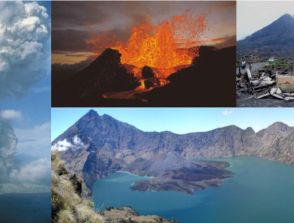
Since May 2018, the island of Mayotte has experienced significant seismic activity related to submarine volcanic activity that is thought to have begun about 50 km off the island’s coast (Feuillet et al., 2021). The eruptive site discovered in 2019 revealed the formation of a new submarine edifice, created in less than a year, rising at least 800 m above the ocean floor and located at a depth of 3,500 m. Lava emissions continued until January 2021, accompanied by eruptive plumes. In addition, numerous plumes of fluids rich in liquid CO₂ of magmatic origin have been detected every year since 2019 in the volcanic area known as the “Horseshoe”, located 10 km from Mayotte (Mastin, 2023). This crisis has been monitored by REVOSIMA (Réseau de Surveillance Volcanologique et Sismologique de Mayotte), established by the French government in 2019. Since then, studies have been conducted to produce water height maps estimating the impact of tsunamis associated with various landslide scenarios linked to this seismo-volcanic crisis (Poulain et al., 2022). These maps were built using numerical models simulating submarine landslides based on data collected at the beginning of the crisis (2019–2020). The simulations showed that wave heights along the coast of Mayotte are highly heterogeneous and strongly dependent on the scenario considered, the bathymetry and the coral reef.
This PhD aims to quantify tsunami hazards in an active seismo-volcanic and climate change context through a collaborative, interdisciplinary approach at the interface of geology, geophysics, numerical modeling, and geography. It will integrate all data and knowledge acquired since the beginning of the crisis and rely on state-of-the-art numerical codes. One of the expected outcomes will be the identification and quantification of high-risk and protected areas in response to tsunamis generated by potential gravitational instabilities offshore Mayotte.
The first key step in tsunami risk assessment is the identification of tsunami sources corresponding to the most probable and most damaging scenarios. Observations from REVOSIMA have shown an evolution of seismo-volcanic activity since 2020, requiring a reassessment of instability scenarios. In particular, the spatial distribution of seismicity and the continuous development of liquidCO₂ plumes discovered during successive oceanographic campaigns in the “Horseshoe” area—located closer to the coast of Petite Terre than the new volcano—suggest new scenarios that have not yet been simulated. During this PhD, unique and dense datasets collected within the framework of REVOSIMA will be used to conduct geological investigations and refine our understanding of the volcanic chain identified offshore Mayotte. Slope instability scenarios involving the numerous volcanic cones and edifices in the area will be revisited in light of this new knowledge.
Special attention will be given to the Horseshoe area, where numerous volcanic cones were formed during previous eruptions along eruptive fissures associated with the volcanic chain east of Mayotte, including within the last few thousand years. In particular, renewed volcanic activity on slopes closer to the island could trigger submarine instabilities and/or caldera collapse in the case of an explosive eruption releasing large volumes of magma (as recently observed at the Hunga Tonga–Hunga Ha’apai volcano), potentially generating tsunamis. This work will investigate these new scenarios, especially those involving collapse calderas under hypothetical future eruptive activity near Mayotte. Additionally, seismic data collected since 2018 from both onshore and offshore stations may help identify the seismic signature of potential landslides. The study will also explore far-field scenarios involving more distant landslides.
To numerically simulate the considered gravitational instabilities, topographies and volcanic cones will need to be reconstructed, and digital elevation models modified. The DIGDEM code developed by Marc Peruzzetto will be used for this purpose. This reconstruction step is particularly delicate, as it requires integrating geological data to produce realistic scenarios. Initial work will be conducted using 50 m resolution digital terrain models, followed by higher-resolution models. Smoothing procedures may be necessary to avoid numerical artifacts.
A non-hydrostatic multilayer model describing landslide dynamics on complex bathymetry (HySEA) will be used to simulate tsunamis generated by destabilization in the Horseshoe area. This work will benefit from long-standing collaborations with mathematicians. Innovative mathematical and numerical methods (Delgado-Sanchez et al., 2020), developed and tested in simplified configurations by our multidisciplinary geophysics/mathematics team with international collaborators, will be implemented in the HySEA multilayer model—one of the most advanced numerical tools for simulating landslide-generated tsunami waves (Macias et al., 2020). Simulated water velocities will be used to produce hazard maps. Previous studies have shown that even when wave heights on land (e.g., at the airport runway) remain moderate (~1 m), the hazard can still be significant (Poulain et al., 2022). Sensitivity tests will be carried out by varying parameters such as volume, source geometry, source depth, and friction laws.
This research will be conducted within a multidisciplinary team involved in the ROM project (Risques telluriques OutreMer), funded by the PEPR IRIMA program, which recently started. One objective of this project is to develop a state-of-the-art toolchain for tsunami hazards in seismo-volcanic and tectonic contexts, capable of providing damage estimates and decision-support materials for integrated tsunami risk management (before, during, and after events), useful for spatial planning and risk awareness initiatives. This PhD will contribute to this effort within a team bringing together experts in Earth sciences, geophysics, geology, geotechnics, mathematics, numerical modeling, and social sciences.
The results of this work will feed directly into further studies (conducted by geographers) focusing on territorial and human vulnerabilities to support decision-making. The PhD candidate will be integrated into this co-constructed framework aimed at coupling risk and prevention models. For instance, high-resolution datasets representing buildings, infrastructure, strategic assets, and coastal bathymetry—taking into account damage caused by Cyclone Chido—will be collected to perform highly detailed simulations of tsunami impacts on Mayotte’s coastline, based on the developed scenarios. Various public policy and spatial planning options for Mayotte could then be tested and their consequences simulated. Particular attention will be given to mapping and graphical representation of results, which will be presented to REVOSIMA and relevant authorities involved in the project.
Delgado-Sánchez, J. M., Bouchut, F., Fernández-Nieto, E. D., Mangeney, A., and Narbona-Reina, G. (2020). A two-layer shallow flow model with two axes of integration, well-balanced discretization and application to submarine avalanches. J. Comput. Phys., 406, article no. 109186.
Feuillet, N., Jorry, S.J., Crawford, W.C., Deplus, C., Thinon, I., et al., 2021. Birth of a large volcanic edifice offshore Mayotte via lithosphere-scale dyke intrusion. Nature Geoscience, 14, 787 – 795.
Macías, J., Castro, M. J., Ortega, S., and González-Vida, J. M. (2020). Performance assessment of Tsunami-HySEA model for NTHMP tsunami currents benchmarking. Field cases. Ocean Model., 152, article no. 101645.
Mastin, M. 2023. Fluid and gas emissions in a submarine eruption context offshore Mayotte Island : geochemical impact on the water column. Sciences de la Terre. Université de Bretagne occidentale – Brest. Français. NNT : 2023BRES0049 HAL Id: tel-04394229 https://theses.hal.science/tel-04394229v1
Poulain, P. Le Friant, Pedreros, R., Mangeney, A., Filippini, A., et al., 2022. Numerical simulation of submarine landslides and generated tsunamis : application to the on-going Mayotte seismo-volcanic crisis. Comptes Rendus Géoscience, 354, S2.