Citizen / General public
Researcher
Student / Future student
Company
Public partner
Journalist
Teacher / Pupil

What’s happening in Titan’s equatorial belt?

Over the last thirteen years (2004 - 2017), the Cassini-Huygens mission has brought about a real revolution in the exploration of Titan, Saturn's largest moon. This mission has revealed that Titan is - in many respects - very similar to Earth.
What’s happening in Titan’s equatorial belt?

Publication date: 16/05/2018

Press, Research

Related themes : Origins

Titan is a frozen version of Earth, where methane acts like water, and water ice can be as hard as rock. Despite its exotic characteristics, Titan undergoes a rich variety of atmospheric and surface processes that are analogous to those on our planet. As Titan is entirely enveloped by a dense atmosphere composed of nitrogen, methane and solid organic particles, direct observation of its surface is only possible via radar data, as well as infrared data in specific wavelength intervals. SAR images from Cassini’s RADAR experiment have made it possible to identify several types of terrain on the Moon and to assess their overall distribution, particularly lakes and dunes. Lakes are mainly confined around the poles, while dunes dominate the equatorial belt. While the nature and geographical distribution of these major geomorphological units seem to be well understood thanks to the SAR images, the precise morphology, but also the origin and nature of the material making up or covering these different terrains, on which the understanding of Titan’s geological and climatic history is based, are still widely debated.

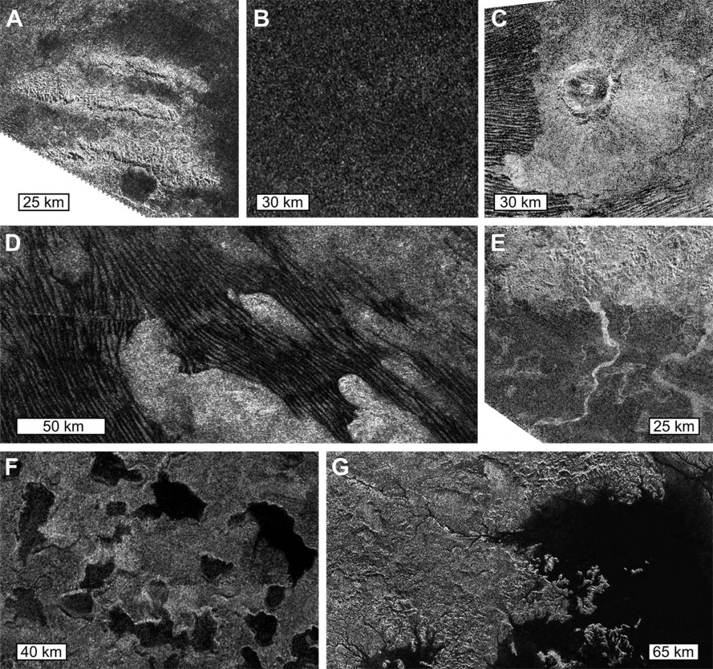
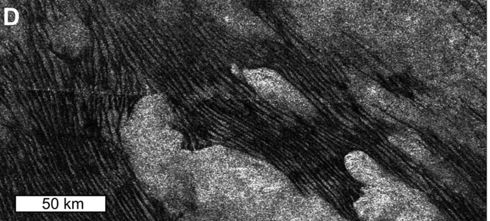
Some examples of terrain on Titan seen on Cassini SAR images, including (A) mountain ranges surrounded by plains, (B) undifferentiated plains, (C) an impact crater, (D) dunes, (E) rivers, (F) small lakes and (G) a zoom on the second largest sea, Ligeia Mare. The SAR images were acquired during Titan flybys (A, B) T43 in May 2008, (C) T77 in June 2011, (D) T21 in December 2006, (E) T44 in May 2008, (F) T19 in October, and finally (G) T28 in April 2007. Note that Titan flybys are noted with the target abbreviation 'T' and the flyby number.
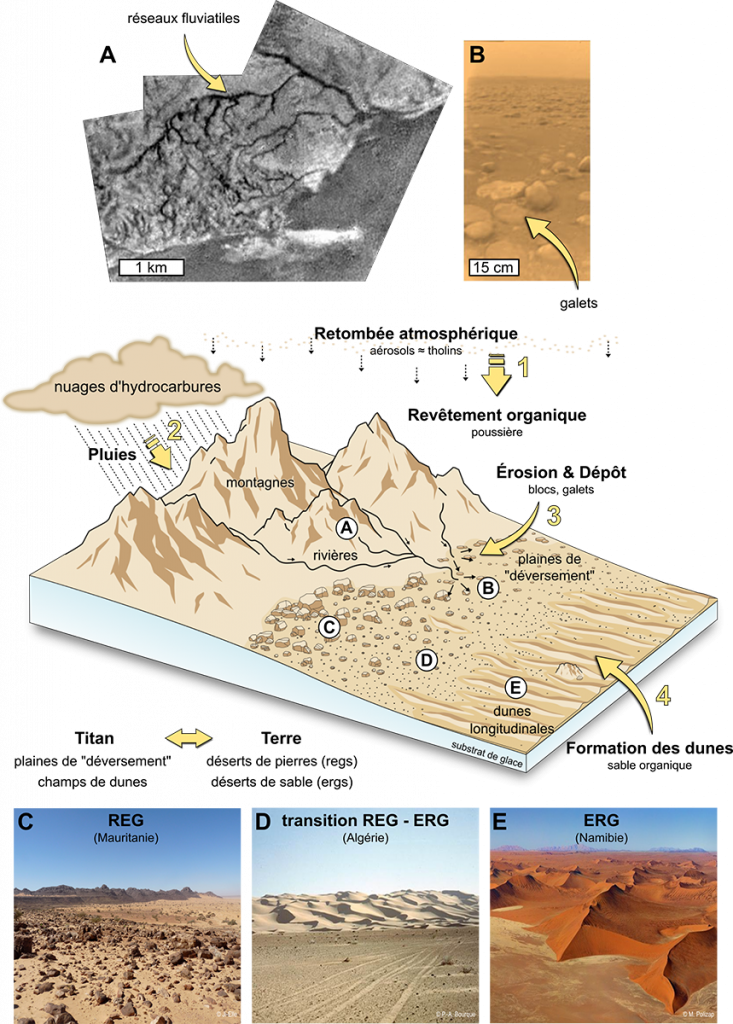
Diagram showing a transition from high terrain (mountains and crater flanks) to low terrain (depositional plains and dune fields) in Titan's equatorial belt. This transition involves landforms very similar to those observed in terrestrial deserts, except that the sedimentary materials on Titan are organic products from atmospheric fallout and grains of water ice from the substrate. Image (A) shows fluvial networks identified by Huygens' DISR imager during its descent towards the surface (4 January 2005), while (B) is an image of the surface acquired by the probe after its landing (Tomasko et al., 2008). Images (C) and (E) show terrestrial analogues of the terrains studied in Brossier et al. (2018): (C) is a stony desert also called reg and (E) is a sandy desert also called erg. Credits: (C) Ji-Elle, (D) P-A. Bourque, and (E) M. Poliza.

The polar lakes are filled with liquid hydrocarbons, whereas the compositions of the other terrains have not been clearly defined to date. In Brossier et al. (2018) we attempt to retrieve this information and provide new insights into the nature, origin and evolution of the main terrains observed in the particular (arid to semi-arid) climatic context of low latitudes, such as dunes, mountains and plains. To this end, we have applied a newly updated radiative transfer model (Maltagliati et al., 2015) to infrared observations acquired by the Visual and Infrared Mapping Spectrometer (VIMS) on board Cassini in order to assess atmospheric effects and recover the surface contribution (albedo) for each of the regions of interest. In order to complete this compositional analysis by comparing the surface albedo on Titan with candidate compounds, we have developed and used a spectral mixing model to create a vast library of binary mixtures for water ice and atmospheric organic solids, the two supposedly major candidates for the surface composition on Titan, by varying the mixture fractions and grain sizes. Indeed, water ice is assumed to form the top layer/crust of Titan (Tobie et al., 2005), while tholins are produced photochemically in the atmosphere and have been deposited on the surface since geological time (Tomasko et al., 2008).

Finally, by bringing together our compositional analysis and geomorphological observations, we have provided new insights into the formation and evolution of Titan’s equatorial terrains. The differences in the compositions found are thought to be due to differences in mechanical erosion and granulometric sorting by alluvial processes, and mixing by eolian processes. Organic deposits or atmospheric ‘dust’ tend to dominate Titan’s surface, covering mountains and plains.

This organic material can be transported downstream by fluvial processes following hydrocarbon rainfall, and then blown by winds to form dunes in the lowlands, exactly as in the transition zones found in terrestrial deserts, from mountainous terrain with river beds (wadis) to stony deserts (regs) and sandy deserts (ergs). Thus, through this study, we have shown that the low latitudes of Titan undergo geological processes very similar to those occurring in arid regions on Earth, in agreement with the predictions of climate models for Titan.

Ref: Brossier, J. F., Rodriguez, S., Cornet, T., Lucas, A., Radebaugh, J., Maltagliati, L. et al. (2018). Geological evolution of Titan’s equatorial regions: Possible nature and origin of the dune material. Journal of Geophysical Research (Planets). 123. DOI: 10.1029/2017JE005399

Latest news
Jérôme Vergne becomes the new Director of the OVSM-IPGP
Committed to the various aspects of observing and monitoring telluric phenomena, Jérôme Vergne joined the IPGP on 1 July 2024 as Director of the Volca...
Evidence of magmatically induced faults at the East Pacific Rise
By comparison of ultra-high-resolution 3-D seismic imagery and bathymetry data collected at the East Pacific Rise (EPR) 9º50'N, researchers reveal the...
Charles Le Losq appointed member of the Institut Universitaire de France
The role of the Institut Universitaire de France (IUF) is to encourage the development of high-level research in universities and to strengthen interd...
NASA will measure earthquakes on the Moon using technologies developed for the InSight mission on Mars
The technology of the two seismometers that are part of NASA's Farside Seismic Suite instrument has detected more than a thousand earthquakes on the R...