EROSAT
Start: 01/01/2020
Campaign and mission
Coordinators : Antoine Lucas
Host institutions :
CNRS, IPGP, and Université Paris Cité, LabEx UnivEarthS
Related teams :
External Envelopes Geochemistry, Planetology and Space Sciences
Related themes :
Earth System Science
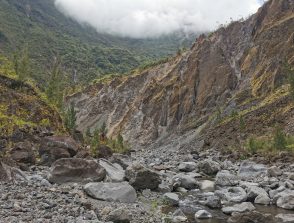
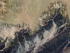
Because of their role in erosion and sediment supply in rivers, gravity instabilities are one of the most important geophysical processes in explaining the transformation of the Earth’s surface, and thus the evolution of the landscape. By allowing the percolation of surface runoff through highly fragmented sedimentary rocks, these instabilities create conditions for chemical weathering, which is an important sink for atmospheric carbon.
The EROSAT project aims to assess the role of slope processes in sediment and solute fluxes from watersheds, and to study their impact on the critical area of the Guadeloupe islands, where erosion and weathering rates are among the highest in the world. Thanks to an interdisciplinary approach combining ObsEra data, geochemical analysis and remote sensing at multiple scales, EROSAT will allow a stepwise analysis between gravity instability and sediment/solute loading in rivers. Ultimately, EROSAT will provide a quantitative model of sediment and solute transport by gravity instability.