Two Weeks of Instability Before the Collapse
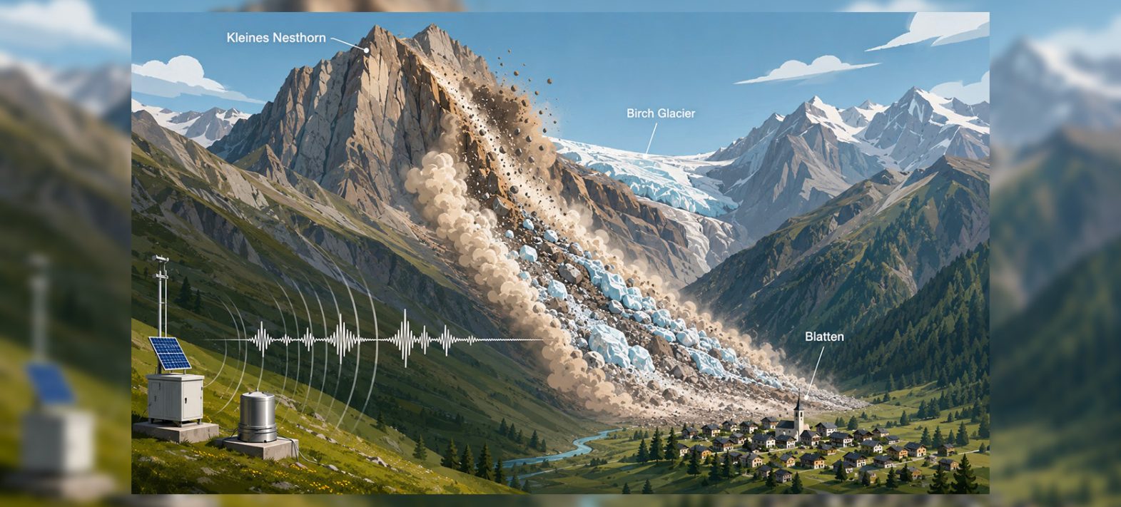
The 28 May disaster was preceded by over two weeks of increasing activity. Rockfalls from the Kleines Nesthorn, located approximately 600 metres above the Birch Glacier, progressively accumulated several million cubic metres of material on the ice. In response to this escalation, the roughly 300 inhabitants of Blatten were evacuated before the main collapse.
This sequence was continuously recorded by a seismological station located about five kilometres from the site. Using a machine learning method capable of grouping signals with similar characteristics, the scientists identified approximately 700 precursor events. Two main categories were distinguished: rockfalls from the cliff face and small avalanches mixing glacier ice with debris already deposited on its surface. The analysis shows that these events became increasingly frequent as the disaster approached, with some also growing in volume.
By comparing the energy and duration of seismic signals with flow simulations, the team estimated the origin, volume, and mobility of these events. This method indicates that approximately 3.5 to 4 million cubic metres of rock had already been mobilised before the main collapse; an estimate consistent with the topographical changes measured after the event.
Reconstructing the Avalanche from Ground Vibrations
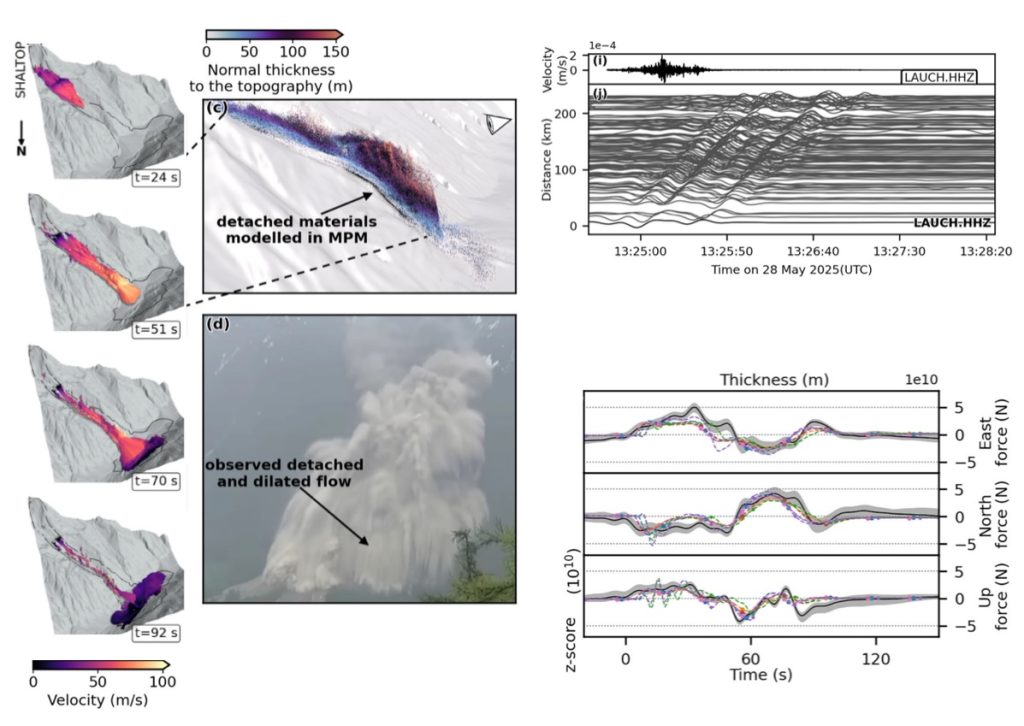
The main collapse generated vibrations recorded hundreds of kilometres away. The researchers used long-period signals measured by several seismological stations to determine the forces exerted by the avalanche on the ground. These forces provide direct insight into the accelerations and decelerations of its centre of mass.
The event, which unfolded over approximately 100 seconds, was broken down into several phases: initial detachment and acceleration, passage through a narrow gorge, collision with the valley floor and the opposite slope, followed by the progressive redistribution and deposition of materials. This reconstruction goes beyond merely observing the final deposit. It reveals how the avalanche accelerated, changed direction, endured impacts against the topography, and slowed before coming to a halt.
Researchers at the IPGP used the SHALTOP numerical model to simulate the movement of the rock and ice mass over the valley’s complex topography. This model describes the flow as a layer of material whose movement depends on factors such as slope, relief, and friction.
The simulations were compared with two types of independent observations: the extent and thickness of the deposits measured after the event, and the evolution of forces reconstructed from seismic signals. The friction laws typically used to represent large dry rock avalanches fail to accurately reproduce the distance travelled and the distribution of deposits. The best results were obtained when the effective friction varied during the flow and reached extremely low values during certain critical phases.
This effective friction, however, does not correspond to the direct measurement of a single physical mechanism. Instead, it represents the combined effect, at the scale of the entire avalanche, of the various processes that either facilitate or hinder its movement.
The avalanche contained approximately 3 million cubic metres of ice. Interactions between the rock and ice likely played a significant role in its high mobility. However, the presence of ice alone is insufficient to explain the complex dynamics and deposit distribution.
Intense rock fragmentation during impacts, the potential production of water from ice melting, and the development of high water pressures between grains may also have reduced resistance to movement. Field observations indicate that some parts of the deposit were damp shortly after the event. The analysed samples also contained a significant proportion of fine particles and exhibited low permeability. These characteristics could have slowed water drainage and temporarily maintained high pressures within the material.
These findings are consistent with water-weakened mobility, but they do not allow for a precise determination of the respective contributions of ice, fragmentation, melting, and water pressure. One of the study’s key conclusions is that significant weakening occurred, while distinguishing this robust finding from the physical mechanisms that remain to be clarified.
The IPGP’s Contribution
The IPGP’s contribution focused particularly on the numerical modelling of the avalanche using SHALTOP, the exploration of different friction laws, and the quantitative comparison between simulations, observed deposits, and forces derived from seismic data. This combination of seismology and modelling makes it possible to assess simulations not only based on the final shape of the deposit but also on whether the model correctly reproduces the avalanche’s dynamics during its movement.
In a context of glacier retreat and permafrost degradation, events involving rock, ice, and water could become more frequent in high mountain regions. The approach developed for Blatten thus provides a reproducible framework for better understanding their mobility and improving the assessment of areas likely to be affected.
The disaster that occurred on 26 August 2026 on the Nepal-Tibet border starkly underscores these stakes. A collapse involving rock and ice propagated through a confined valley, eroding and entraining large quantities of material before interacting with the hydrological network and generating an extremely destructive sediment-laden flood. The human toll, though still provisional, is substantial. While this event differs from Blatten in scale, geometry, and its evolution into a flood, it raises several of the same fundamental questions: How does the presence of ice and water alter the mobility of a moving mass? What role does valley floor erosion play in its amplification? And how can remotely recorded seismic signals be linked to the actual dynamics of these cascading events?
The tools combining seismology, satellite imagery, and numerical modelling used to study Blatten can precisely help answer these questions. They are now being deployed at the IPGP to analyse the Nepal-Tibet event and, ultimately, to better understand and anticipate these cascades of processes that can transform a localised collapse into a catastrophe affecting valleys located tens of kilometres downstream.